
Spenden
Rüste dich für dein nächstes Abenteuer:
Als Amazon-Partner verdient diese Seite an qualifizierten Käufen, ohne dass Ihnen zusätzliche Kosten entstehen.
Topografische Karte Geismar
Klicken Sie auf die Karte, um die Höhe anzuzeigen.
Spenden
Rüste dich für dein nächstes Abenteuer:
Als Amazon-Partner verdient diese Seite an qualifizierten Käufen, ohne dass Ihnen zusätzliche Kosten entstehen.
Geismar
Geismar is an unincorporated community in Ascension Parish, Louisiana, United States and is at the heart of Louisiana's chemical corridor. The community is part of the Baton Rouge metropolitan statistical area. Geismar is south of Prairieville and west of Gonzales. The community has Three schools, Dutchtown Primary School, Dutchtown Middle School and Dutchtown High School, which are ranked among the top schools in the state of Louisiana. The Mississippi River flows to the southeast along the southwest side of the community. The area is vulnerable to hurricanes and tropical systems due to its low elevation and its proximity to the coast of southeast Louisiana.
Spenden
Rüste dich für dein nächstes Abenteuer:
Als Amazon-Partner verdient diese Seite an qualifizierten Käufen, ohne dass Ihnen zusätzliche Kosten entstehen.
Über diese Karte
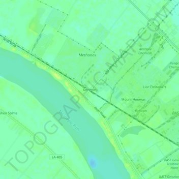
Name: Topografische Karte Geismar, Höhe, Relief.
Ort: Geismar, Ascension Parish, Louisiana, United States (30.18436 -91.04260 30.22436 -91.00260)
Durchschnittliche Höhe: 7 m
Minimale Höhe: -1 m
Maximale Höhe: 17 m
Spenden
Rüste dich für dein nächstes Abenteuer:
Als Amazon-Partner verdient diese Seite an qualifizierten Käufen, ohne dass Ihnen zusätzliche Kosten entstehen.
Andere topografische Karten
Klicken Sie auf eine Karte, um ihre Topografie, ihre Höhe und ihr Relief anzuzeigen.