Geolokalisieren

Topografische Karte Lexington

Interaktive Karte

Klicken Sie auf die Karte, um die Höhe anzuzeigen.

Über diese Karte

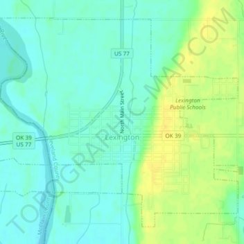
Name: Topografische Karte Lexington, Höhe, Relief.

Ort: Lexington, Cleveland County, Oklahoma, United States (35.00367 -97.35495 35.02954 -97.31805)

Durchschnittliche Höhe: 321 m

Minimale Höhe: 312 m

Maximale Höhe: 334 m

Andere topografische Karten

Klicken Sie auf eine Karte, um ihre Topografie, ihre Höhe und ihr Relief anzuzeigen.

Norman

United States > Oklahoma > Cleveland County

Norman, Cleveland County, Oklahoma, United States

Durchschnittliche Höhe: 358 m

Etowah

United States > Oklahoma > Cleveland County

Etowah, Cleveland County, Oklahoma, United States

Durchschnittliche Höhe: 334 m

Slaughterville

United States > Oklahoma > Cleveland County

Slaughterville, Cleveland County, Oklahoma, 73051, United States

Durchschnittliche Höhe: 344 m

Moore

United States > Oklahoma > Cleveland County

Moore, Cleveland County, Oklahoma, 73160, United States

Durchschnittliche Höhe: 373 m

Lake Thunderbird

United States > Oklahoma > Cleveland County > Norman

Lake Thunderbird, Norman, Cleveland County, Oklahoma, United States

Durchschnittliche Höhe: 334 m

Noble

United States > Oklahoma > Cleveland County

Noble, Cleveland County, Oklahoma, 73068, United States

Durchschnittliche Höhe: 344 m

SW Oklahoma City Sludge Lagoon Dam

United States > Oklahoma > Cleveland County > Oklahoma City

SW Oklahoma City Sludge Lagoon Dam, Oklahoma City, Cleveland County, Oklahoma, 73165, United States

Durchschnittliche Höhe: 348 m

Norman

United States > Oklahoma > Cleveland County > Norman

Norman, Cleveland County, Oklahoma, 73069, United States

Durchschnittliche Höhe: 356 m

Moore

United States > Oklahoma > Cleveland County > Moore > Moore

Moore, Cleveland County, Oklahoma, 73160, United States

Durchschnittliche Höhe: 377 m