
Topografische Karte Ladispoli
Klicken Sie auf die Karte, um die Höhe anzuzeigen.
Über diese Karte
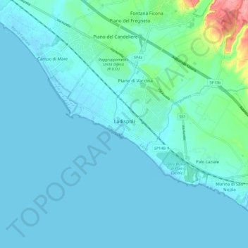
Name: Topografische Karte Ladispoli, Höhe, Relief.
Ort: Ladispoli, Roma Capitale, Lazio, Italy (41.92482 12.04220 41.98073 12.15284)
Durchschnittliche Höhe: 12 m
Minimale Höhe: -2 m
Maximale Höhe: 103 m
Andere topografische Karten
Klicken Sie auf eine Karte, um ihre Topografie, ihre Höhe und ihr Relief anzuzeigen.
Rome
Italy > Lazio > Roma Capitale
Although the city centre is about 24 km (15 mi) inland from the Tyrrhenian Sea, the city territory extends to the shore, where the south-western district of Ostia is located. The altitude of the central part of Rome ranges from 13 m (43 ft) above sea level (at the base of the Pantheon) to 139 m (456 ft) above…
Durchschnittliche Höhe: 78 m