Geolokalisieren

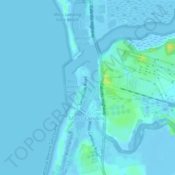
Topografische Karte Moss Landing

Klicken Sie auf die Karte, um die Höhe anzuzeigen.

Moss Landing

Moss Landing, formerly Moss, is an unincorporated community and census-designated place (CDP) in Monterey County, California, United States. As of the 2020 census, Moss Landing had a population of 237. It is located 18 miles (29 km) north-northeast of Monterey, at an elevation of 10 feet (3.048 m). It is on the shore of Monterey Bay, at the mouth of Elkhorn Slough and at the head of the submarine Monterey Canyon.

Wikipedia (CC-BY-SA 3.0)

Über diese Karte

Name: Topografische Karte Moss Landing, Höhe, Relief.

Ort: Moss Landing, Thompson, Moss Landing, Monterey County, California, United States (36.79019 -121.79378 36.81695 -121.78318)

Durchschnittliche Höhe: 1 m

Minimale Höhe: -6 m

Maximale Höhe: 18 m

Rüste dich für dein nächstes Abenteuer:

☀️Sonnenschutz für Outdoor - Sonnenschutzcremes und Accessoires für lange Touren
🎒Kleine Daypacks - Kompakte Rucksäcke für Tagesausflüge
🧨Notfall‑ & Survival‑Ausrüstung - Essentielle Ausrüstung für Notsituationen draußen
🦶Orthopädische Einlegesohlen - Zusätzlicher Support für lange Tage auf steinigem Untergrund
🔌Powerbanks für Outdoor - Robuste Akkus für GPS und Smartphone unterwegs

Als Amazon-Partner verdient diese Seite an qualifizierten Käufen, ohne dass Ihnen zusätzliche Kosten entstehen.