
Topografische Karte Kaufman County
Klicken Sie auf die Karte, um die Höhe anzuzeigen.
Über diese Karte
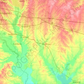
Name: Topografische Karte Kaufman County, Höhe, Relief.
Ort: Kaufman County, Texas, United States (32.35479 -96.52945 32.84173 -96.07555)
Durchschnittliche Höhe: 132 m
Minimale Höhe: 93 m
Maximale Höhe: 187 m
Andere topografische Karten
Klicken Sie auf eine Karte, um ihre Topografie, ihre Höhe und ihr Relief anzuzeigen.
Georgetown
United States > Texas > Georgetown
The city is located on the northeastern edge of Texas Hill Country. Portions of Georgetown are located on either side of the Balcones Escarpment, a fault line in which the areas roughly east of IH-35 are flat and characterized by having black, fertile soils of the Blackland Prairie, and the west side of the…
Durchschnittliche Höhe: 219 m
Belton
United States > Texas > Bell County > Belton > Belton
Belton is located 60 miles (97 km) north of Austin, 137 miles (220 km) south of Dallas, and 184 miles (296 km) west of Houston. It is near the center of Bell County at 31°3′32″N 97°27′48″W / 31.05889°N 97.46333°W / 31.05889; -97.46333 (31.058904, -97.463382). It is at the point where the…
Durchschnittliche Höhe: 176 m
Bergheim
United States > Texas > Kendall County
Bergheim is an unincorporated community in eastern Kendall County, Texas, United States known for its German-Texan culture and heritage. It lies along State Highway 46 east of the city of Boerne, the county seat of Kendall County. Its elevation is 1,437 feet (438 m). Although Bergheim is unincorporated, it has…
Durchschnittliche Höhe: 419 m
Hodges Addition Colonia
United States > Texas > Jim Wells County > Sandia
Durchschnittliche Höhe: 40 m
Enchanted Rock
United States > Texas > Llano County
Enchanted Rock is a pink granite mountain located in the Llano Uplift about 17 miles (27 km) north of Fredericksburg, Texas and 24 miles (39 km) south of Llano, Texas, United States. Enchanted Rock State Natural Area, which includes Enchanted Rock and surrounding land, spans the border between Gillespie and…
Durchschnittliche Höhe: 453 m
Padre Island National Seashore
United States > Texas > Kenedy County > Corpus Christi
Durchschnittliche Höhe: 5 m
Mission Hills Ranch
United States > Texas > Comal County > New Braunfels
Durchschnittliche Höhe: 287 m
Sundance Square Plaza
United States > Texas > Tarrant County > Fort Worth
Durchschnittliche Höhe: 178 m
McKinney Falls State Park
United States > Texas > Travis County > Austin
Durchschnittliche Höhe: 171 m
Choke Canyon State Park - Calliham Unit
United States > Texas > McMullen County > Calliham
Durchschnittliche Höhe: 67 m