
Topografische Karte Flat Lick
Interaktive Karte
Klicken Sie auf die Karte, um die Höhe anzuzeigen.
Über diese Karte
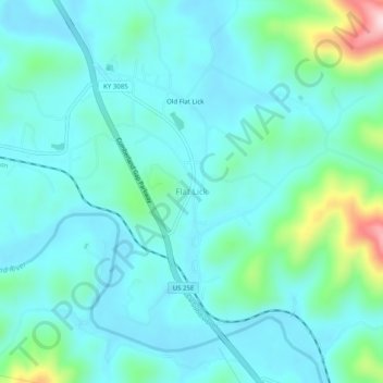
Name: Topografische Karte Flat Lick, Höhe, Relief.
Ort: Flat Lick, Knox County, Kentucky, 40935, United States (36.80898 -83.79020 36.84898 -83.75020)
Durchschnittliche Höhe: 349 m
Minimale Höhe: 294 m
Maximale Höhe: 607 m
Andere topografische Karten
Klicken Sie auf eine Karte, um ihre Topografie, ihre Höhe und ihr Relief anzuzeigen.
Walker
United States > Kentucky > Knox County
Walker, Knox County, Kentucky, 40997, United States
Durchschnittliche Höhe: 403 m
Hinkle
United States > Kentucky > Knox County
Hinkle, Knox County, Kentucky, 40915, United States
Durchschnittliche Höhe: 368 m
Big Rock
United States > Kentucky > Knox County
Big Rock, Knox County, Kentucky, 40923, United States
Durchschnittliche Höhe: 355 m
Barbourville
United States > Kentucky > Knox County
Barbourville, Knox County, Kentucky, 40906, United States
Durchschnittliche Höhe: 323 m
Baughman
United States > Kentucky > Knox County > Baughman
Baughman, Knox County, Kentucky, 40915, United States
Durchschnittliche Höhe: 360 m