
Spenden
Rüste dich für dein nächstes Abenteuer:
Als Amazon-Partner verdient diese Seite an qualifizierten Käufen, ohne dass Ihnen zusätzliche Kosten entstehen.
Topografische Karte Smith Lake
Klicken Sie auf die Karte, um die Höhe anzuzeigen.
Spenden
Rüste dich für dein nächstes Abenteuer:
Als Amazon-Partner verdient diese Seite an qualifizierten Käufen, ohne dass Ihnen zusätzliche Kosten entstehen.
Über diese Karte
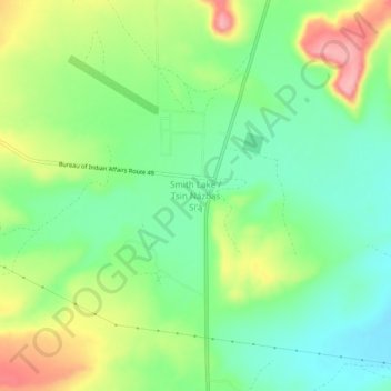
Name: Topografische Karte Smith Lake, Höhe, Relief.
Durchschnittliche Höhe: 2’221 m
Minimale Höhe: 2’175 m
Maximale Höhe: 2’296 m
Spenden
Rüste dich für dein nächstes Abenteuer:
Als Amazon-Partner verdient diese Seite an qualifizierten Käufen, ohne dass Ihnen zusätzliche Kosten entstehen.
Andere topografische Karten
Klicken Sie auf eine Karte, um ihre Topografie, ihre Höhe und ihr Relief anzuzeigen.
Gallup
United States > New Mexico > McKinley County
Gallup, like most of the interior Mountain West, has a cool semiarid climate (Köppen BSk). The summers are hot during the day, but the high altitude and low humidity mean that nights remain distinctly cool; as late as July 2, 1997, the temperature fell to 31 °F (−1 °C). Despite the large diurnal…
Durchschnittliche Höhe: 2’067 m
Ramah
United States > New Mexico > McKinley County > Ramah
Lying at 6926 feet above sea level, Ramah is considered by some as a high desert, but at higher elevations in includes tall pines, sandstone cliffs, and timber covered mountains. Much of the lower landscape in the surrounding area is covered with lava flows from the chain of volcanos to the south. Intermixed…
Durchschnittliche Höhe: 2’184 m
Spenden
Rüste dich für dein nächstes Abenteuer:
Als Amazon-Partner verdient diese Seite an qualifizierten Käufen, ohne dass Ihnen zusätzliche Kosten entstehen.
Ramah
United States > New Mexico > McKinley County > Ramah
Lying at 6,926 feet (2,111 m) above sea level, Ramah is considered by some as a high desert, but at higher elevations it includes tall pines, sandstone cliffs, and timber-covered mountains. Much of the lower landscape in the surrounding area is covered with lava flows from the chain of volcanos to the south.
Durchschnittliche Höhe: 2’184 m
Spenden
Rüste dich für dein nächstes Abenteuer:
Als Amazon-Partner verdient diese Seite an qualifizierten Käufen, ohne dass Ihnen zusätzliche Kosten entstehen.
Gallup
United States > New Mexico > McKinley County
Gallup, like most of the interior Mountain West, has a cool semiarid climate (Köppen BSk). The summers are hot during the day, but the high altitude and low humidity mean that nights remain distinctly cool; as late as July 2, 1997, the temperature fell to 31 °F (−1 °C). Despite the large diurnal…
Durchschnittliche Höhe: 2’067 m
Rock Springs
United States > New Mexico > McKinley County > Rock Springs
Durchschnittliche Höhe: 2’022 m
Crownpoint
United States > New Mexico > McKinley County
Crownpoint is in central McKinley County along New Mexico State Road 371, which leads south 23 miles (37 km) to Thoreau and Interstate 40, and north 83 miles (134 km) to Farmington. The community sits at an elevation of 6,851 feet (2,088 m) on land that drains toward the Chaco River 30 miles (48 km) to the…
Durchschnittliche Höhe: 2’099 m
Spenden
Rüste dich für dein nächstes Abenteuer:
Als Amazon-Partner verdient diese Seite an qualifizierten Käufen, ohne dass Ihnen zusätzliche Kosten entstehen.
Gallup
United States > New Mexico > McKinley County
Gallup, like most of the interior Mountain West, has a cool semiarid climate (Köppen BSk). The summers are hot during the day, but the high altitude and low humidity mean that nights remain distinctly cool; as late as July 2, 1997, the temperature fell to 31 °F (−1 °C). Despite the large diurnal…
Durchschnittliche Höhe: 2’067 m