
Topografische Karte Hardyville
Interaktive Karte
Klicken Sie auf die Karte, um die Höhe anzuzeigen.
Über diese Karte
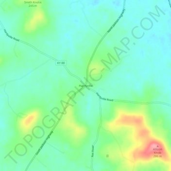
Name: Topografische Karte Hardyville, Höhe, Relief.
Ort: Hardyville, Hart County, Kentucky, United States (37.23422 -85.80608 37.27422 -85.76608)
Durchschnittliche Höhe: 212 m
Minimale Höhe: 183 m
Maximale Höhe: 286 m
Andere topografische Karten
Klicken Sie auf eine Karte, um ihre Topografie, ihre Höhe und ihr Relief anzuzeigen.
Lone Star
United States > Kentucky > Hart County
Lone Star, Hart County, Kentucky, 42713, United States
Durchschnittliche Höhe: 228 m
Uno
United States > Kentucky > Hart County
Uno, Hart County, Kentucky, United States
Durchschnittliche Höhe: 201 m
Jonesville
United States > Kentucky > Hart County
Jonesville, Hart County, Kentucky, 42757, United States
Durchschnittliche Höhe: 241 m
Canmer
United States > Kentucky > Hart County
Canmer, Hart County, Kentucky, United States
Durchschnittliche Höhe: 185 m
Bee
United States > Kentucky > Hart County
Bee, Hart County, Kentucky, 42729, United States
Durchschnittliche Höhe: 230 m
Big Windy
United States > Kentucky > Hart County
Big Windy, Hart County, Kentucky, 42729, United States
Durchschnittliche Höhe: 206 m
Hammonville
United States > Kentucky > Hart County
Hammonville, Hart County, Kentucky, United States
Durchschnittliche Höhe: 232 m
Northtown
United States > Kentucky > Hart County
Northtown, Hart County, Kentucky, United States
Durchschnittliche Höhe: 225 m
Woodsonville
United States > Kentucky > Hart County
Woodsonville, Hart County, Kentucky, 42765, United States
Durchschnittliche Höhe: 183 m
Munfordville
United States > Kentucky > Hart County
Munfordville, Hart County, Kentucky, United States
Durchschnittliche Höhe: 191 m
Kessinger
United States > Kentucky > Hart County
Kessinger, Hart County, Kentucky, 42765, United States
Durchschnittliche Höhe: 260 m
Rowletts
United States > Kentucky > Hart County
Rowletts, Hart County, Kentucky, United States
Durchschnittliche Höhe: 197 m
Horse Cave
United States > Kentucky > Hart County
Horse Cave, Hart County, Kentucky, United States
Durchschnittliche Höhe: 207 m
Bonnieville
United States > Kentucky > Hart County
Bonnieville, Hart County, Kentucky, 42713, United States
Durchschnittliche Höhe: 212 m
Cub Run
United States > Kentucky > Hart County
Cub Run, Hart County, Kentucky, 42729, United States
Durchschnittliche Höhe: 225 m
Monroe
United States > Kentucky > Hart County
Monroe, Hart County, Kentucky, 42746, United States
Durchschnittliche Höhe: 210 m