
Topografische Karte Greensboro
Interaktive Karte
Klicken Sie auf die Karte, um die Höhe anzuzeigen.
Über diese Karte
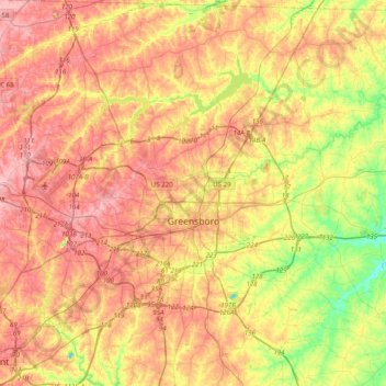
Name: Topografische Karte Greensboro, Höhe, Relief.
Ort: Greensboro, Guilford County, North Carolina, United States (35.97581 -80.01788 36.21536 -79.62117)
Durchschnittliche Höhe: 242 m
Minimale Höhe: 171 m
Maximale Höhe: 299 m
Andere topografische Karten
Klicken Sie auf eine Karte, um ihre Topografie, ihre Höhe und ihr Relief anzuzeigen.
Five Points Park
United States > North Carolina > Guilford County > High Point
Five Points Park, High Point, Guilford County, North Carolina, United States
Durchschnittliche Höhe: 264 m
Garden Homes
United States > North Carolina > Guilford County > Greensboro
Garden Homes, Greensboro, Guilford County, North Carolina, 27408, United States
Durchschnittliche Höhe: 265 m
Pennydale
United States > North Carolina > Guilford County > Greensboro
Pennydale, Greensboro, Guilford County, North Carolina, 27407, United States
Durchschnittliche Höhe: 260 m