
Topografische Karte Kootenay National Park
Interaktive Karte
Klicken Sie auf die Karte, um die Höhe anzuzeigen.
Über diese Karte
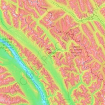
Name: Topografische Karte Kootenay National Park, Höhe, Relief.
Durchschnittliche Höhe: 1’832 m
Minimale Höhe: 786 m
Maximale Höhe: 3’410 m
L'altitude varie de 918 m à 3 424 m au sommet de la Deltaform Mountain. Le parc s'étend sur 1 406 km2.
Andere topografische Karten
Klicken Sie auf eine Karte, um ihre Topografie, ihre Höhe und ihr Relief anzuzeigen.
Radium Hot Springs
Canada > Colombie-Britannique > Regional District of East Kootenay
Radium Hot Springs, Regional District of East Kootenay, Colombie-Britannique, V0A 1M0, Canada
Durchschnittliche Höhe: 913 m
Elkford
Canada > Colombie-Britannique > Regional District of East Kootenay
Elkford, Regional District of East Kootenay, Colombie-Britannique, Canada
Durchschnittliche Höhe: 1’895 m
Fernie
Canada > Colombie-Britannique > Regional District of East Kootenay > Fernie
Fernie, Regional District of East Kootenay, Colombie-Britannique, V0B 1M0, Canada
Durchschnittliche Höhe: 1’551 m
Shuswap
Canada > Colombie-Britannique > Regional District of East Kootenay > Area F (Columbia Lake/Windermere Lake) > Shuswap
Shuswap, Area F (Columbia Lake/Windermere Lake), Regional District of East Kootenay, Colombie-Britannique, V0A 1K3, Canada
Durchschnittliche Höhe: 926 m