
Topografische Karte Davenport
Interaktive Karte
Klicken Sie auf die Karte, um die Höhe anzuzeigen.
Über diese Karte
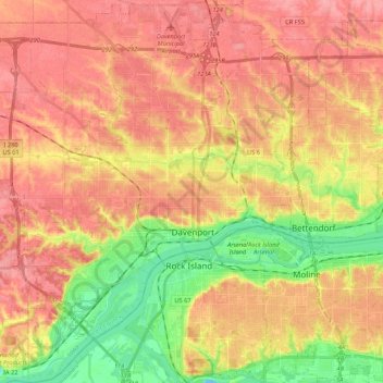
Name: Topografische Karte Davenport, Höhe, Relief.
Ort: Davenport, Scott County, Iowa, United States (41.46063 -90.68793 41.62029 -90.49082)
Durchschnittliche Höhe: 205 m
Minimale Höhe: 157 m
Maximale Höhe: 237 m
Andere topografische Karten
Klicken Sie auf eine Karte, um ihre Topografie, ihre Höhe und ihr Relief anzuzeigen.
Park View
United States > Iowa > Scott County
Park View, Scott County, Iowa, United States
Durchschnittliche Höhe: 235 m
Buffalo
United States > Iowa > Scott County
Buffalo, Buffalo Township, Scott County, Iowa, 52728, United States
Durchschnittliche Höhe: 205 m
Sheridan Township
United States > Iowa > Scott County
Sheridan Township, Scott County, Iowa, 52748, United States
Durchschnittliche Höhe: 231 m
Bettendorf
United States > Iowa > Scott County > Pleasant Valley Township
Bettendorf, Pleasant Valley Township, Scott County, Iowa, 52722, United States
Durchschnittliche Höhe: 207 m
Pleasant Valley Township
United States > Iowa > Scott County
Pleasant Valley Township, Scott County, Iowa, United States
Durchschnittliche Höhe: 198 m
Le Claire
United States > Iowa > Scott County
Le Claire, Le Claire Township, Scott County, Iowa, United States
Durchschnittliche Höhe: 200 m
Walcott
United States > Iowa > Scott County > Walcott
Walcott, Blue Grass Township, Scott County, Iowa, United States
Durchschnittliche Höhe: 227 m
Eldridge
United States > Iowa > Scott County
Eldridge, Sheridan Township, Scott County, Iowa, 52748, United States
Durchschnittliche Höhe: 234 m
Davenport
United States > Iowa > Scott County > Davenport
Davenport, Scott County, Iowa, 52801, United States
Durchschnittliche Höhe: 212 m
Blue Grass
United States > Iowa > Scott County
Blue Grass, Blue Grass Township, Scott County, Iowa, United States
Durchschnittliche Höhe: 239 m
Long Grove
United States > Iowa > Scott County
Long Grove, Scott County, Iowa, United States
Durchschnittliche Höhe: 235 m