
Spenden
Rüste dich für dein nächstes Abenteuer:
Als Amazon-Partner verdient diese Seite an qualifizierten Käufen, ohne dass Ihnen zusätzliche Kosten entstehen.
Topografische Karte Byron
Klicken Sie auf die Karte, um die Höhe anzuzeigen.
Spenden
Rüste dich für dein nächstes Abenteuer:
Als Amazon-Partner verdient diese Seite an qualifizierten Käufen, ohne dass Ihnen zusätzliche Kosten entstehen.
Byron
Byron is located in Byron Township at the junction of Illinois Route 72 and Illinois Route 2. Byron's topography includes a man-made prairie and the Rock River that passes through the town. It is generally flat and is ideal for farming in most regions. According to the 2010 census, Byron has a total area of 3.572 square miles (9.25 km2), of which 3.57 square miles (9.25 km2) (or 99.94%) is land and 0.002 square miles (0.01 km2) (or 0.06%) is water.
Spenden
Rüste dich für dein nächstes Abenteuer:
Als Amazon-Partner verdient diese Seite an qualifizierten Käufen, ohne dass Ihnen zusätzliche Kosten entstehen.
Über diese Karte
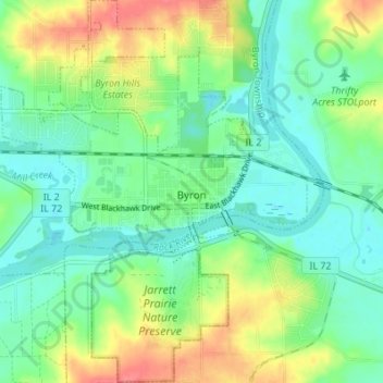
Name: Topografische Karte Byron, Höhe, Relief.
Durchschnittliche Höhe: 226 m
Minimale Höhe: 204 m
Maximale Höhe: 267 m
Spenden
Rüste dich für dein nächstes Abenteuer:
Als Amazon-Partner verdient diese Seite an qualifizierten Käufen, ohne dass Ihnen zusätzliche Kosten entstehen.
Andere topografische Karten
Klicken Sie auf eine Karte, um ihre Topografie, ihre Höhe und ihr Relief anzuzeigen.