Geolokalisieren

Topografische Karte Taboada dos Freires

Klicken Sie auf die Karte, um die Höhe anzuzeigen.

Über diese Karte

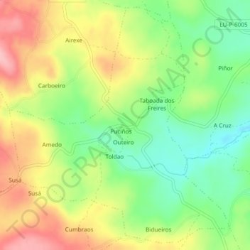
Name: Topografische Karte Taboada dos Freires, Höhe, Relief.

Ort: Taboada dos Freires, Taboada, Chantada, Lugo, Galicia, España (42.68376 -7.84195 42.70924 -7.80950)

Durchschnittliche Höhe: 627 m

Minimale Höhe: 563 m

Maximale Höhe: 701 m

Andere topografische Karten

Klicken Sie auf eine Karte, um ihre Topografie, ihre Höhe und ihr Relief anzuzeigen.

A Barrela

España > Galicia > Chantada

Durchschnittliche Höhe: 627 m

Argozón

España > Galicia > Chantada > Chantada

Durchschnittliche Höhe: 742 m

Vilaver

España > Galicia > Chantada > Chantada

Durchschnittliche Höhe: 531 m

San Cristovo

España > Galicia > Chantada > Taboada

Durchschnittliche Höhe: 686 m

Vielen Dank für die Unterstützung dieser Website ❤️
Spenden

Rüste dich für dein nächstes Abenteuer:

Als Amazon-Partner verdient diese Seite an qualifizierten Käufen, ohne dass Ihnen zusätzliche Kosten entstehen.

Puricela

España > Galicia > Chantada > Taboada

Durchschnittliche Höhe: 518 m

Río Búbal

España > Galicia > Chantada > A Peroxa

Durchschnittliche Höhe: 561 m

Nogueira de Abaixo

España > Galicia > Chantada > Chantada

Durchschnittliche Höhe: 411 m

Bouzoa

España > Galicia > Chantada > Taboada

Durchschnittliche Höhe: 718 m

O Cotarelo

España > Galicia > Chantada

Durchschnittliche Höhe: 662 m

Coto de Ceduras

España > Galicia > Chantada > Taboada

Durchschnittliche Höhe: 512 m

Adá

España > Galicia > Chantada > Chantada

Durchschnittliche Höhe: 670 m

Muradelle

España > Galicia > Chantada > Chantada

Durchschnittliche Höhe: 608 m

Taboada

España > Galicia > Chantada

Durchschnittliche Höhe: 530 m

Carballós

España > Galicia > Chantada > Carballós

Durchschnittliche Höhe: 472 m

Limiñón

España > Galicia > Chantada > Chantada

Durchschnittliche Höhe: 648 m

Centulle

España > Galicia > Chantada > Chantada

Durchschnittliche Höhe: 546 m

Penasillás

España > Galicia > Chantada

Durchschnittliche Höhe: 692 m

A Barrela

España > Galicia > Chantada

Durchschnittliche Höhe: 627 m

Rüste dich für dein nächstes Abenteuer:

🧭Kompass & Navigationshilfen - Präzise Kompasse für Orientierung ohne GPS
🍵Camping‑Kochsets - Komplettsets zum Kochen bei Outdoor‑Touren
🩳Leichte Wanderhosen - Bequeme und strapazierfähige Hosen für Wanderungen
🆘Biwaksäcke - Lebensrettender Schutz bei Wetterumstürzen im Gebirge
🔦LED-Taschenlampen - Zuverlässige Lichtquelle für Notfälle und Camping

Als Amazon-Partner verdient diese Seite an qualifizierten Käufen, ohne dass Ihnen zusätzliche Kosten entstehen.