
Topografische Karte Marbach am Neckar
Interaktive Karte
Klicken Sie auf die Karte, um die Höhe anzuzeigen.
Über diese Karte
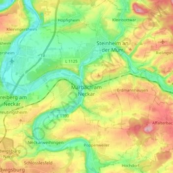
Name: Topografische Karte Marbach am Neckar, Höhe, Relief.
Durchschnittliche Höhe: 251 m
Minimale Höhe: 179 m
Maximale Höhe: 355 m
The city (Stadt) of Marbach am Neckar covers 18.06 square kilometers (6.97 sq mi) of the district of Ludwigsburg in a total of four separate exclaves. Marbach is, according to government urban planning, part of the Stuttgart Metropolitan Region. Marbach's municipal areas are physically located in the basin of the Neckar, with the exception of its easternmost exclave, which lies in the Swabian-Franconian Forest. The lowest elevation above sea level in the municipal area, 190 meters (620 ft) Normalnull (NN), is found where the Neckar flows out of Marbach and into Benningen am Neckar. The highest elevation, 355 meters (1,165 ft), is found in the east, at the top of the Bülzberg.