
Topografische Karte Chilliwack
Klicken Sie auf die Karte, um die Höhe anzuzeigen.
Über diese Karte
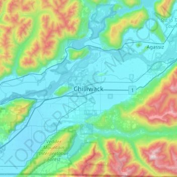
Name: Topografische Karte Chilliwack, Höhe, Relief.
Durchschnittliche Höhe: 381 m
Minimale Höhe: -1 m
Maximale Höhe: 1’986 m
Andere topografische Karten
Klicken Sie auf eine Karte, um ihre Topografie, ihre Höhe und ihr Relief anzuzeigen.
Area A (Boston Bar/North Bend/Canyon Alpine)
Canada > British Columbia > Fraser Valley Regional District
Durchschnittliche Höhe: 1’260 m
Chilliwack Lake
Canada > British Columbia > Fraser Valley Regional District > Area E (Chilliwack River Valley)
Durchschnittliche Höhe: 1’152 m
Mission
Canada > British Columbia > Fraser Valley Regional District
The western part of the district, the Stave Valley, is largely rural and forested but its watercourse is home to what was the largest hydroelectric project in British Columbia until the Bridge River Power Project opened in 1961. It was built by the British Columbia Electric Railway (BCER) to provide power to…
Durchschnittliche Höhe: 345 m
Glacier Lake
Canada > British Columbia > Fraser Valley Regional District > Area C (Sasquatch Country)
Durchschnittliche Höhe: 614 m
Cultus Lake
Canada > British Columbia > Fraser Valley Regional District > Area H (Cultus Lake/Columbia Valley) > Cultus Lake
Durchschnittliche Höhe: 191 m
Area E (Chilliwack River Valley)
Canada > British Columbia > Fraser Valley Regional District
Durchschnittliche Höhe: 1’032 m
Harrison River
Canada > British Columbia > Fraser Valley Regional District > Kent > Harrison Mills
Durchschnittliche Höhe: 45 m
Sumas River
Canada > British Columbia > Fraser Valley Regional District > Abbotsford
Durchschnittliche Höhe: 167 m
Harrison Hot Springs
Canada > British Columbia > Fraser Valley Regional District
Durchschnittliche Höhe: 203 m
Harrison Lake
Canada > British Columbia > Fraser Valley Regional District > Area C (Sasquatch Country)
Durchschnittliche Höhe: 815 m
Stave Lake
Canada > British Columbia > Fraser Valley Regional District > Mission
Durchschnittliche Höhe: 573 m
Chehalis Lake
Canada > British Columbia > Fraser Valley Regional District > Area C (Sasquatch Country)
Durchschnittliche Höhe: 735 m
Sloquet Creek
Canada > British Columbia > Fraser Valley Regional District > Area C (Sasquatch Country)
Durchschnittliche Höhe: 255 m
Campbell Lake
Canada > British Columbia > Fraser Valley Regional District > Kent
Durchschnittliche Höhe: 528 m
Area F (McConnell Creek/Hatzic Prairie)
Canada > British Columbia > Fraser Valley Regional District
Durchschnittliche Höhe: 832 m
Falls Lake
Canada > British Columbia > Fraser Valley Regional District > Area B (South Fraser Canyon/Sunshine Valley)
Durchschnittliche Höhe: 1’512 m
Jones Lake
Canada > British Columbia > Fraser Valley Regional District > Area D (Popkum/Bridal Falls/Wahleach)
Durchschnittliche Höhe: 956 m
Stoney Creek Park
Canada > British Columbia > Fraser Valley Regional District > Abbotsford
Durchschnittliche Höhe: 40 m
Hicks Lake
Canada > British Columbia > Fraser Valley Regional District > Kent
Durchschnittliche Höhe: 377 m
Area B (South Fraser Canyon/Sunshine Valley)
Canada > British Columbia > Fraser Valley Regional District
Durchschnittliche Höhe: 1’174 m
Area H (Cultus Lake/Columbia Valley)
Canada > British Columbia > Fraser Valley Regional District
Durchschnittliche Höhe: 566 m
Sumas Prairie
Canada > British Columbia > Fraser Valley Regional District > Abbotsford
Durchschnittliche Höhe: 159 m
Serpentine Lake
Canada > British Columbia > Fraser Valley Regional District > Area B (South Fraser Canyon/Sunshine Valley)
Durchschnittliche Höhe: 960 m
Isabel Lake
Canada > British Columbia > Fraser Valley Regional District > Area F (McConnell Creek/Hatzic Prairie)
Durchschnittliche Höhe: 687 m
Vedder River
Canada > British Columbia > Fraser Valley Regional District > Chilliwack
Durchschnittliche Höhe: 110 m
Area C (Sasquatch Country)
Canada > British Columbia > Fraser Valley Regional District
Durchschnittliche Höhe: 988 m
Chehalis River
Canada > British Columbia > Fraser Valley Regional District > Area C (Sasquatch Country)
Durchschnittliche Höhe: 424 m
Misty Icefield
Canada > British Columbia > Fraser Valley Regional District > Area F (McConnell Creek/Hatzic Prairie)
Durchschnittliche Höhe: 1’800 m
Mamquam Icefield
Canada > British Columbia > Fraser Valley Regional District > Area F (McConnell Creek/Hatzic Prairie)
Durchschnittliche Höhe: 1’925 m
Hope Slide
Canada > British Columbia > Fraser Valley Regional District > Area B (South Fraser Canyon/Sunshine Valley)
Durchschnittliche Höhe: 1’160 m
Area G (Deroche/Dewdney/Sumas Mountain)
Canada > British Columbia > Fraser Valley Regional District > Area G (Deroche/Dewdney/Sumas Mountain)
Durchschnittliche Höhe: 211 m
Mission
Canada > British Columbia > Fraser Valley Regional District
The western part of the district, the Stave Valley, is largely rural and forested but its watercourse is home to what was the largest hydroelectric project in British Columbia until the Bridge River Power Project opened in 1961. It was built by the British Columbia Electric Railway (BCER) to provide power to…
Durchschnittliche Höhe: 345 m
Sumas Prairie
Canada > British Columbia > Fraser Valley Regional District > Abbotsford
Durchschnittliche Höhe: 159 m
Area D (Popkum/Bridal Falls/Wahleach)
Canada > British Columbia > Fraser Valley Regional District
Durchschnittliche Höhe: 948 m
Area B (South Fraser Canyon/Sunshine Valley)
Canada > British Columbia > Fraser Valley Regional District
Durchschnittliche Höhe: 1’174 m
Mission
Canada > British Columbia > Fraser Valley Regional District
The western part of the district, the Stave Valley, is largely rural and forested but its watercourse is home to what was the largest hydroelectric project in British Columbia until the Bridge River Power Project opened in 1961. It was built by the British Columbia Electric Railway (BCER) to provide power to…
Durchschnittliche Höhe: 345 m
Turner Glacier
Canada > British Columbia > Fraser Valley Regional District > Area C (Sasquatch Country)
Durchschnittliche Höhe: 2’183 m
Ryder Lake
Canada > British Columbia > Fraser Valley Regional District > Chilliwack
Durchschnittliche Höhe: 255 m
Harrison-Chehalis Wildlife Management Area
Canada > British Columbia > Fraser Valley Regional District > Area C (Sasquatch Country) > Harrison Mills
Durchschnittliche Höhe: 187 m
Misty Icefield
Canada > British Columbia > Fraser Valley Regional District > Area F (McConnell Creek/Hatzic Prairie)
Durchschnittliche Höhe: 1’800 m
Area D (Popkum/Bridal Falls/Wahleach)
Canada > British Columbia > Fraser Valley Regional District
Durchschnittliche Höhe: 948 m
Area D (Popkum/Bridal Falls/Wahleach)
Canada > British Columbia > Fraser Valley Regional District
Durchschnittliche Höhe: 948 m
Mission
Canada > British Columbia > Fraser Valley Regional District
The western part of the district, the Stave Valley, is largely rural and forested but its watercourse is home to what was the largest hydroelectric project in British Columbia until the Bridge River Power Project opened in 1961. It was built by the British Columbia Electric Railway (BCER) to provide power to…
Durchschnittliche Höhe: 345 m
Harrison Hot Springs
Canada > British Columbia > Fraser Valley Regional District
Durchschnittliche Höhe: 206 m
Area B (South Fraser Canyon/Sunshine Valley)
Canada > British Columbia > Fraser Valley Regional District
Durchschnittliche Höhe: 1’174 m