
Topografische Karte Sunny Valley
Interaktive Karte
Klicken Sie auf die Karte, um die Höhe anzuzeigen.
Über diese Karte
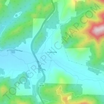
Name: Topografische Karte Sunny Valley, Höhe, Relief.
Durchschnittliche Höhe: 476 m
Minimale Höhe: 345 m
Maximale Höhe: 898 m
Andere topografische Karten
Klicken Sie auf eine Karte, um ihre Topografie, ihre Höhe und ihr Relief anzuzeigen.
Grants Pass
United States > Oregon > Josephine County
Grants Pass, Josephine County, Oregon, United States
Durchschnittliche Höhe: 374 m
Cave Junction
United States > Oregon > Josephine County
Cave Junction, Josephine County, Oregon, United States
Durchschnittliche Höhe: 410 m
Wilderville
United States > Oregon > Josephine County
Wilderville, Josephine County, Oregon, United States
Durchschnittliche Höhe: 364 m
O'Brien
United States > Oregon > Josephine County
O'Brien, Josephine County, Oregon, 97534, United States
Durchschnittliche Höhe: 454 m
Redwood
United States > Oregon > Josephine County
Redwood, Josephine County, Oregon, United States
Durchschnittliche Höhe: 300 m
Fruitdale
United States > Oregon > Josephine County > Grants Pass
Fruitdale, Grants Pass, Josephine County, Oregon, 97506, United States
Durchschnittliche Höhe: 346 m
Grants Pass
United States > Oregon > Josephine County
Grants Pass, Josephine County, Oregon, United States
Durchschnittliche Höhe: 377 m
Williams
United States > Oregon > Josephine County
Williams, Josephine County, Oregon, 97544, United States
Durchschnittliche Höhe: 484 m
Merlin
United States > Oregon > Josephine County
Merlin, Josephine County, Oregon, 57526, United States
Durchschnittliche Höhe: 308 m
Galice
United States > Oregon > Josephine County > Galice
Galice, Josephine County, Oregon, United States
Durchschnittliche Höhe: 402 m
Wolf Creek
United States > Oregon > Josephine County
Wolf Creek, Josephine County, Oregon, 97497, United States
Durchschnittliche Höhe: 522 m