
Spenden
Rüste dich für dein nächstes Abenteuer:
Als Amazon-Partner verdient diese Seite an qualifizierten Käufen, ohne dass Ihnen zusätzliche Kosten entstehen.
Topografische Karte Layton
Klicken Sie auf die Karte, um die Höhe anzuzeigen.
Spenden
Rüste dich für dein nächstes Abenteuer:
Als Amazon-Partner verdient diese Seite an qualifizierten Käufen, ohne dass Ihnen zusätzliche Kosten entstehen.
Über diese Karte
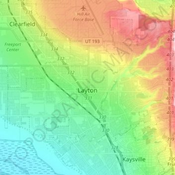
Name: Topografische Karte Layton, Höhe, Relief.
Ort: Layton, Davis County, Utah, United States (41.03668 -112.03586 41.11657 -111.90119)
Durchschnittliche Höhe: 1’373 m
Minimale Höhe: 1’278 m
Maximale Höhe: 1’551 m
Spenden
Rüste dich für dein nächstes Abenteuer:
Als Amazon-Partner verdient diese Seite an qualifizierten Käufen, ohne dass Ihnen zusätzliche Kosten entstehen.
Andere topografische Karten
Klicken Sie auf eine Karte, um ihre Topografie, ihre Höhe und ihr Relief anzuzeigen.
Mountains Meadows
United States > Utah > Davis County > North Salt Lake
Durchschnittliche Höhe: 1’411 m
Antelope Island
United States > Utah > Davis County
The island is accessible via a 7-mile causeway from Syracuse in Davis County. Access from Interstate 15 is via exit 332, then west along Antelope Drive (SR-108). The island's shore (all but west side of the island) is mostly flat with beaches and plains to the base of the mountains on the island. These steep…
Durchschnittliche Höhe: 1’306 m
Mountains Meadows
United States > Utah > Davis County > North Salt Lake
Durchschnittliche Höhe: 1’411 m
Spenden
Rüste dich für dein nächstes Abenteuer:
Als Amazon-Partner verdient diese Seite an qualifizierten Käufen, ohne dass Ihnen zusätzliche Kosten entstehen.
Spenden
Rüste dich für dein nächstes Abenteuer:
Als Amazon-Partner verdient diese Seite an qualifizierten Käufen, ohne dass Ihnen zusätzliche Kosten entstehen.
Mount Lebannon Acres
United States > Utah > Davis County > Centerville > Rosedale
Durchschnittliche Höhe: 1’464 m
Mountains Meadows
United States > Utah > Davis County > North Salt Lake
Durchschnittliche Höhe: 1’411 m
Farmington
United States > Utah > Davis County > Farmington > Farmington
Durchschnittliche Höhe: 1’595 m