
Spenden
Rüste dich für dein nächstes Abenteuer:
Als Amazon-Partner verdient diese Seite an qualifizierten Käufen, ohne dass Ihnen zusätzliche Kosten entstehen.
Topografische Karte Marshall
Klicken Sie auf die Karte, um die Höhe anzuzeigen.
Spenden
Rüste dich für dein nächstes Abenteuer:
Als Amazon-Partner verdient diese Seite an qualifizierten Käufen, ohne dass Ihnen zusätzliche Kosten entstehen.
Marshall
Marshall is situated at latitude 44.47N and longitude -95.78W, with an elevation of 354 meters (1,161 feet) above sea level. The city is 150 km (93 mi) northeast of Sioux Falls, South Dakota, and 238 km (148 mi) southwest of Minneapolis. It is in the Central Standard time zone and has the ZIP code 56258. According to the United States Census Bureau, the city has an area of 10.08 square miles (26.11 km2), of which 10.07 square miles (26.08 km2) is land and 0.01 square miles (0.03 km2) is water. It is in a predominantly rural and agricultural area that was originally an expanse of northern tallgrass prairie. The Redwood River's flood plain begins in Marshall.
Spenden
Rüste dich für dein nächstes Abenteuer:
Als Amazon-Partner verdient diese Seite an qualifizierten Käufen, ohne dass Ihnen zusätzliche Kosten entstehen.
Über diese Karte
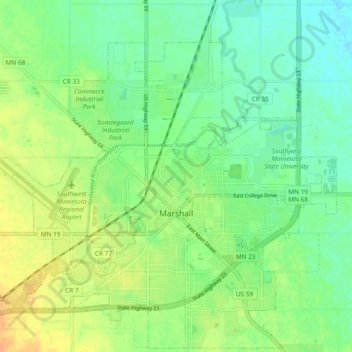
Name: Topografische Karte Marshall, Höhe, Relief.
Ort: Marshall, Lyon County, Minnesota, 56258, United States (44.42124 -95.83960 44.48676 -95.74587)
Durchschnittliche Höhe: 353 m
Minimale Höhe: 340 m
Maximale Höhe: 370 m
Spenden
Rüste dich für dein nächstes Abenteuer:
Als Amazon-Partner verdient diese Seite an qualifizierten Käufen, ohne dass Ihnen zusätzliche Kosten entstehen.