
Topografische Karte Dormer Mountain
Interaktive Karte
Klicken Sie auf die Karte, um die Höhe anzuzeigen.
Über diese Karte
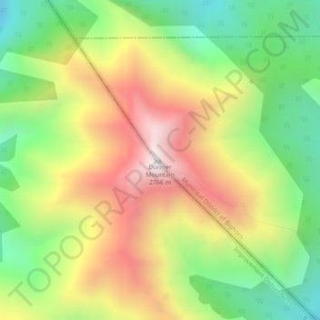
Name: Topografische Karte Dormer Mountain, Höhe, Relief.
Durchschnittliche Höhe: 2’243 m
Minimale Höhe: 1’810 m
Maximale Höhe: 2’756 m
Andere topografische Karten
Klicken Sie auf eine Karte, um ihre Topografie, ihre Höhe und ihr Relief anzuzeigen.
Kananaskis
Canada > Alberta > Municipal District of Bighorn > Kananaskis
Kananaskis, Municipal District of Bighorn, Alberta, T0L 2C0, Canada
Durchschnittliche Höhe: 1’426 m
Gap Lake
Canada > Alberta > Municipal District of Bighorn
Gap Lake, Municipal District of Bighorn, Alberta, Canada
Durchschnittliche Höhe: 1’424 m
Waiparous
Canada > Alberta > Municipal District of Bighorn
Waiparous, Municipal District of Bighorn, Alberta, Canada
Durchschnittliche Höhe: 1’338 m
Exshaw
Canada > Alberta > Municipal District of Bighorn
Exshaw, Municipal District of Bighorn, Alberta, T0L 2C0, Canada
Durchschnittliche Höhe: 1’420 m
South Ghost Peak
Canada > Alberta > Municipal District of Bighorn
South Ghost Peak, Municipal District of Bighorn, Alberta, Canada
Durchschnittliche Höhe: 2’240 m