
Topografische Karte Bouteville
Interaktive Karte
Klicken Sie auf die Karte, um die Höhe anzuzeigen.
Über diese Karte
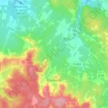
Name: Topografische Karte Bouteville, Höhe, Relief.
Durchschnittliche Höhe: 79 m
Minimale Höhe: 30 m
Maximale Höhe: 154 m
Les sommets de ces deux escapements culminent dans la commune respectivement à 80 m d'altitude pour celle du nord, et 150 m pour celle du sud. Elles forment des collines assez hautes, surtout au sud, et sont boisées. Entre ces deux cuestas se trouve la plaine viticole, formant un palier d'environ 60 m d'altitude, et c'est là que passe l'ancienne voie romaine Saintes-Périgueux, le chemin Boisné, longeant parfaitement ces reliefs.
Andere topografische Karten
Klicken Sie auf eine Karte, um ihre Topografie, ihre Höhe und ihr Relief anzuzeigen.
L'Échassier
France > Nouvelle-Aquitaine > Charente > Châteaubernard
L'Échassier, Châteaubernard, Cognac, Charente, Nouvelle-Aquitaine, France métropolitaine, 16100, France
Durchschnittliche Höhe: 29 m
Merpins
France > Nouvelle-Aquitaine > Charente
Merpins, Cognac, Charente, Nouvelle-Aquitaine, France métropolitaine, 16100, France
Durchschnittliche Höhe: 15 m
Cognac
France > Nouvelle-Aquitaine > Charente
Cognac, Charente, Nouvelle-Aquitaine, France métropolitaine, 16100, France
Durchschnittliche Höhe: 26 m
Édon
France > Nouvelle-Aquitaine > Charente
Édon, Angoulême, Charente, Nouvelle-Aquitaine, France métropolitaine, 16320, France
Durchschnittliche Höhe: 138 m
Brie
France > Nouvelle-Aquitaine > Charente
Brie, Angoulême, Charente, Nouvelle-Aquitaine, France métropolitaine, 16590, France
Durchschnittliche Höhe: 119 m
L'Isle-d'Espagnac
France > Nouvelle-Aquitaine > Charente
L'Isle-d'Espagnac, Angoulême, Charente, Nouvelle-Aquitaine, France métropolitaine, 16340, France
Durchschnittliche Höhe: 75 m
Montbron
France > Nouvelle-Aquitaine > Charente
Montbron, Angoulême, Charente, Nouvelle-Aquitaine, France métropolitaine, 16220, France
Durchschnittliche Höhe: 181 m
Saint-Séverin
France > Nouvelle-Aquitaine > Charente
Saint-Séverin, Angoulême, Charente, Nouvelle-Aquitaine, France métropolitaine, 16390, France
Durchschnittliche Höhe: 78 m
Lefaudie
France > Nouvelle-Aquitaine > Charente > Pressignac
Lefaudie, Pressignac, Confolens, Charente, Nouvelle-Aquitaine, France métropolitaine, 16150, France
Durchschnittliche Höhe: 219 m
Terres-de-Haute-Charente
France > Nouvelle-Aquitaine > Charente > Terres-de-Haute-Charente
Terres-de-Haute-Charente, Confolens, Charente, Nouvelle-Aquitaine, France métropolitaine, 16270, France
Durchschnittliche Höhe: 197 m
Verrières
France > Nouvelle-Aquitaine > Charente > Verrières
Verrières, Cognac, Charente, Nouvelle-Aquitaine, France métropolitaine, 16130, France
Durchschnittliche Höhe: 53 m
Dignac
France > Nouvelle-Aquitaine > Charente > Dignac
Dignac, Angoulême, Charente, Nouvelle-Aquitaine, France métropolitaine, 16410, France
Durchschnittliche Höhe: 162 m
Ars
France > Nouvelle-Aquitaine > Charente > Ars
Ars, Cognac, Charente, Nouvelle-Aquitaine, France métropolitaine, 16130, France
Durchschnittliche Höhe: 20 m
Bonneuil
France > Nouvelle-Aquitaine > Charente > Bonneuil
Bonneuil, Cognac, Charente, Nouvelle-Aquitaine, France métropolitaine, 16120, France
Durchschnittliche Höhe: 107 m
Mouzon
France > Nouvelle-Aquitaine > Charente > Mouzon
Mouzon, Confolens, Charente, Nouvelle-Aquitaine, France métropolitaine, 16310, France
Durchschnittliche Höhe: 261 m
Ruffec
France > Nouvelle-Aquitaine > Charente
Ruffec, Confolens, Charente, Nouvelle-Aquitaine, France métropolitaine, 16700, France
Durchschnittliche Höhe: 117 m
Villefagnan
France > Nouvelle-Aquitaine > Charente
Villefagnan, Confolens, Charente, Nouvelle-Aquitaine, France métropolitaine, 16240, France
Durchschnittliche Höhe: 119 m
Angoulême
France > Nouvelle-Aquitaine > Charente
Angoulême, Charente, Nouvelle-Aquitaine, France métropolitaine, 16000, France
Durchschnittliche Höhe: 73 m
Viville
France > Nouvelle-Aquitaine > Charente > Bellevigne
Viville, Bellevigne, Cognac, Charente, Nouvelle-Aquitaine, France métropolitaine, 16120, France
Durchschnittliche Höhe: 65 m