Topografische Karte Cashion
Interaktive Karte
Klicken Sie auf die Karte, um die Höhe anzuzeigen.
Über diese Karte
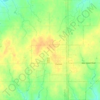
Name: Topografische Karte Cashion, Höhe, Relief.
Ort: Cashion, Kingfisher County, Oklahoma, 73016, United States (35.78390 -97.69206 35.82351 -97.66335)
Durchschnittliche Höhe: 339 m
Minimale Höhe: 320 m
Maximale Höhe: 351 m
Andere topografische Karten
Klicken Sie auf eine Karte, um ihre Topografie, ihre Höhe und ihr Relief anzuzeigen.
Kingfisher
United States > Oklahoma > Kingfisher County
Kingfisher, Kingfisher County, Oklahoma, 73750, United States
Durchschnittliche Höhe: 329 m
Omega
United States > Oklahoma > Kingfisher County
Omega, Kingfisher County, Oklahoma, 73764, United States
Durchschnittliche Höhe: 367 m
Dover
United States > Oklahoma > Kingfisher County
Dover, Kingfisher County, Oklahoma, 73734, United States
Durchschnittliche Höhe: 322 m
Okarche
United States > Oklahoma > Kingfisher County
Okarche, Kingfisher County, Oklahoma, United States
Durchschnittliche Höhe: 374 m
Loyal
United States > Oklahoma > Kingfisher County
Loyal, Kingfisher County, Oklahoma, United States
Durchschnittliche Höhe: 344 m