
Topografische Karte Decatur
Interaktive Karte
Klicken Sie auf die Karte, um die Höhe anzuzeigen.
Über diese Karte
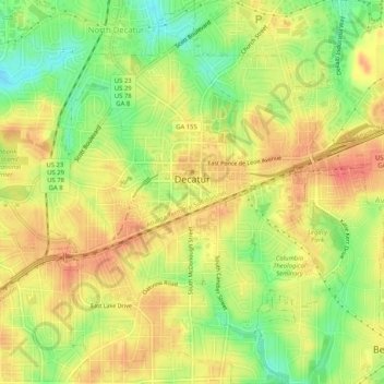
Name: Topografische Karte Decatur, Höhe, Relief.
Ort: Decatur, DeKalb County, Georgia, 30030, United States (33.75097 -84.31577 33.79365 -84.27583)
Durchschnittliche Höhe: 308 m
Minimale Höhe: 275 m
Maximale Höhe: 332 m
Andere topografische Karten
Klicken Sie auf eine Karte, um ihre Topografie, ihre Höhe und ihr Relief anzuzeigen.
Candler Lake
United States > Georgia > DeKalb County > North Decatur
Candler Lake, North Decatur, DeKalb County, Georgia, United States
Durchschnittliche Höhe: 290 m
Dunwoody
United States > Georgia > DeKalb County > Dunwoody
Dunwoody, DeKalb County, Georgia, United States
Durchschnittliche Höhe: 313 m