
Topografische Karte Calamandrana
Interaktive Karte
Klicken Sie auf die Karte, um die Höhe anzuzeigen.
Über diese Karte
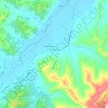
Name: Topografische Karte Calamandrana, Höhe, Relief.
Ort: Calamandrana, Asti, Piedmont, 14042, Italy (44.71378 8.30998 44.75625 8.36817)
Durchschnittliche Höhe: 203 m
Minimale Höhe: 139 m
Maximale Höhe: 428 m
Andere topografische Karten
Klicken Sie auf eine Karte, um ihre Topografie, ihre Höhe und ihr Relief anzuzeigen.
Dusino San Michele
Dusino San Michele, Asti, Piedmont, Italy
Durchschnittliche Höhe: 240 m
San Martino Alfieri
San Martino Alfieri, Asti, Piedmont, Italy
Durchschnittliche Höhe: 196 m
Montemagno
Italy > Piedmont > Asti > Montemagno
Montemagno, Asti, Piedmont, Italy
Durchschnittliche Höhe: 198 m
Nizza Monferrato
Nizza Monferrato, Asti, Piedmont, Italy
Durchschnittliche Höhe: 185 m
Rocchetta Palafea
Rocchetta Palafea, Asti, Piedmont, Italy
Durchschnittliche Höhe: 334 m