
Topografische Karte Puffin Island
Interaktive Karte
Klicken Sie auf die Karte, um die Höhe anzuzeigen.
Über diese Karte
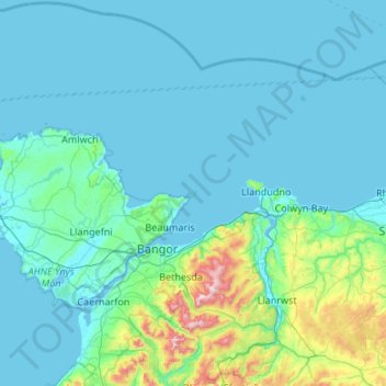
Name: Topografische Karte Puffin Island, Höhe, Relief.
Durchschnittliche Höhe: 94 m
Minimale Höhe: 0 m
Maximale Höhe: 1’059 m
Andere topografische Karten
Klicken Sie auf eine Karte, um ihre Topografie, ihre Höhe und ihr Relief anzuzeigen.
South Stack Lighthouse
United Kingdom > Wales > Isle of Anglesey > Trearddur
South Stack Lighthouse, South Stack Road, Trearddur, Isle of Anglesey, Wales, LL65 1YH, United Kingdom
Durchschnittliche Höhe: 17 m
Cemaes
United Kingdom > Wales > Isle of Anglesey
Cemaes, Isle of Anglesey, Wales, LL67 0EY, United Kingdom
Durchschnittliche Höhe: 20 m
Cefn-bach
United Kingdom > Wales > Isle of Anglesey > Llanddaniel Fab
Cefn-bach, Llanddaniel Fab, Isle of Anglesey, Wales, LL61 6EQ, United Kingdom
Durchschnittliche Höhe: 33 m
Holyhead
United Kingdom > Wales > Isle of Anglesey > Holyhead
Holyhead, Isle of Anglesey, Wales, LL65 1UF, United Kingdom
Durchschnittliche Höhe: 10 m
Llanfairpwllgwyngyll
United Kingdom > Wales > Isle of Anglesey > Llanfairpwllgwyngyll
Llanfairpwllgwyngyll, Isle of Anglesey, Wales, LL61, United Kingdom
Durchschnittliche Höhe: 42 m
Anglesey
United Kingdom > Wales > Isle of Anglesey
Anglesey, Isle of Anglesey, Wales, United Kingdom
Durchschnittliche Höhe: 43 m