
Topografische Karte Glacier National Park
Interaktive Karte
Klicken Sie auf die Karte, um die Höhe anzuzeigen.
Über diese Karte
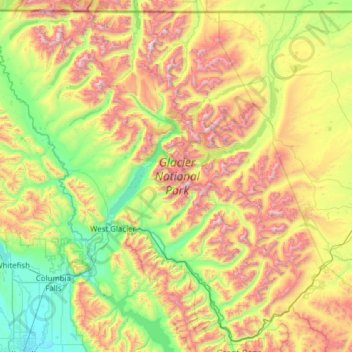
Name: Topografische Karte Glacier National Park, Höhe, Relief.
Durchschnittliche Höhe: 1’594 m
Minimale Höhe: 888 m
Maximale Höhe: 3’051 m
One of the most dramatic evidences of this overthrust is visible in the form of Chief Mountain, an isolated peak on the edge of the eastern boundary of the park rising 2,500 feet (800 m) above the Great Plains. There are six mountains in the park over 10,000 feet (3,000 m) in elevation, with Mount Cleveland at 10,466 feet (3,190 m) being the tallest. Appropriately named Triple Divide Peak sends waters towards the Pacific Ocean, Hudson Bay, and Gulf of Mexico watersheds. This peak can effectively be considered to be the apex of the North American continent, although the mountain is only 8,020 feet (2,444 m) above sea level.
Andere topografische Karten
Klicken Sie auf eine Karte, um ihre Topografie, ihre Höhe und ihr Relief anzuzeigen.
Whitefish
United States > Montana > Flathead County
Whitefish, Flathead County, Montana, United States
Durchschnittliche Höhe: 1’073 m
Marion
United States > Montana > Flathead County
Marion, Flathead County, Montana, United States
Durchschnittliche Höhe: 1’236 m
Kalispell
United States > Montana > Flathead County
Kalispell, Flathead County, Montana, United States
Durchschnittliche Höhe: 934 m
Niarada
United States > Montana > Flathead County
Niarada, Flathead County, Montana, United States
Durchschnittliche Höhe: 1’053 m
Evergreen
United States > Montana > Flathead County
Evergreen, Flathead County, Montana, United States
Durchschnittliche Höhe: 895 m
Condor Peak
United States > Montana > Flathead County
Condor Peak, Flathead County, Montana, United States
Durchschnittliche Höhe: 1’848 m
Columbia Falls
United States > Montana > Flathead County
Columbia Falls, Flathead County, Montana, 59912, United States
Durchschnittliche Höhe: 934 m
Apgar
United States > Montana > Flathead County
Apgar, Flathead County, Montana, 59936, United States
Durchschnittliche Höhe: 1’080 m
Somers
United States > Montana > Flathead County
Somers, Flathead County, Montana, United States
Durchschnittliche Höhe: 915 m
Lakeside
United States > Montana > Flathead County
Lakeside, Flathead County, Montana, 59922, United States
Durchschnittliche Höhe: 1’034 m
Bigfork
United States > Montana > Flathead County
Bigfork, Flathead County, Montana, United States
Durchschnittliche Höhe: 922 m
Bowman Lake
United States > Montana > Flathead County
Bowman Lake, Flathead County, Montana, United States
Durchschnittliche Höhe: 1’639 m
Polebridge
United States > Montana > Flathead County
Polebridge, Flathead County, Montana, 59928, United States
Durchschnittliche Höhe: 1’118 m
Kalispell
United States > Montana > Flathead County > Kalispell
Kalispell, Flathead County, Montana, 59901-4451, United States
Durchschnittliche Höhe: 1’055 m
Canyon Point
United States > Montana > Flathead County
Canyon Point, Flathead County, Montana, United States
Durchschnittliche Höhe: 1’750 m
Graves Creek
United States > Montana > Flathead County
Graves Creek, Flathead County, Montana, United States
Durchschnittliche Höhe: 1’694 m
Lake McDonald
United States > Montana > Flathead County
Lake McDonald, Flathead County, Montana, United States
Durchschnittliche Höhe: 1’209 m
Kila
United States > Montana > Flathead County
Kila, Flathead County, Montana, 59920, United States
Durchschnittliche Höhe: 1’013 m
Lake Ellen Wilson
United States > Montana > Flathead County
Lake Ellen Wilson, Flathead County, Montana, United States
Durchschnittliche Höhe: 2’100 m
West Glacier
United States > Montana > Flathead County
West Glacier, Flathead County, Montana, 59936, United States
Durchschnittliche Höhe: 1’201 m
Coal Creek
United States > Montana > Flathead County
Coal Creek, Flathead County, Montana, United States
Durchschnittliche Höhe: 1’287 m
Cone Peak
United States > Montana > Flathead County
Cone Peak, Flathead County, Montana, United States
Durchschnittliche Höhe: 1’819 m
Heavens Peak
United States > Montana > Flathead County
Heavens Peak, Flathead County, Montana, United States
Durchschnittliche Höhe: 2’055 m