
Topografische Karte Kunigal
Interaktive Karte
Klicken Sie auf die Karte, um die Höhe anzuzeigen.
Kunigal
Kunigal is located at 13°01′N 77°02′E / 13.02°N 77.03°E / 13.02; 77.03. It has an average elevation of 773 metres (2536 feet). It is situated on the National Highway 75 (India) connecting Bengaluru and Mangaluru and State Highway 33 (Karnataka) connecting Tumakuru and Madduru. Kunigal is situated 70 kilometres west of Bengaluru and 115 kilometres north of Mysuru. Recently opened Hassan-Bangalore railway line transverses through Kunigal.
Über diese Karte
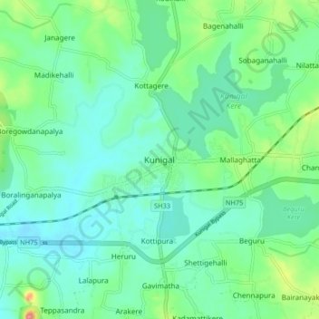
Name: Topografische Karte Kunigal, Höhe, Relief.
Ort: Kunigal, Kunigal taluk, Tumakuru, Karnataka, 572130, India (12.98602 76.98227 13.06602 77.06227)
Durchschnittliche Höhe: 775 m
Minimale Höhe: 751 m
Maximale Höhe: 850 m