
Topografische Karte Sandy Hook
Interaktive Karte
Klicken Sie auf die Karte, um die Höhe anzuzeigen.
Über diese Karte
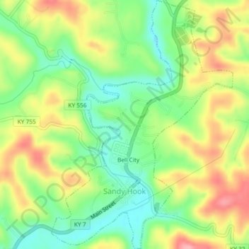
Name: Topografische Karte Sandy Hook, Höhe, Relief.
Ort: Sandy Hook, Elliott County, Kentucky, United States (38.07983 -83.13701 38.10848 -83.11043)
Durchschnittliche Höhe: 261 m
Minimale Höhe: 207 m
Maximale Höhe: 327 m
Andere topografische Karten
Klicken Sie auf eine Karte, um ihre Topografie, ihre Höhe und ihr Relief anzuzeigen.
Culver
United States > Kentucky > Elliott County
Culver, Elliott County, Kentucky, United States
Durchschnittliche Höhe: 271 m
Stark
United States > Kentucky > Elliott County
Stark, Elliott County, Kentucky, United States
Durchschnittliche Höhe: 285 m
Ibex
United States > Kentucky > Elliott County
Ibex, Elliott County, Kentucky, United States
Durchschnittliche Höhe: 249 m
Newfoundland
United States > Kentucky > Elliott County
Newfoundland, Elliott County, Kentucky, 41171, United States
Durchschnittliche Höhe: 259 m
Isonville
United States > Kentucky > Elliott County
Isonville, Elliott County, Kentucky, 41149, United States
Durchschnittliche Höhe: 275 m