
Topografische Karte Kenmare
Interaktive Karte
Klicken Sie auf die Karte, um die Höhe anzuzeigen.
Über diese Karte
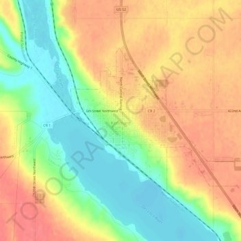
Name: Topografische Karte Kenmare, Höhe, Relief.
Ort: Kenmare, Ward County, North Dakota, United States (48.66370 -102.09456 48.68655 -102.03737)
Durchschnittliche Höhe: 577 m
Minimale Höhe: 541 m
Maximale Höhe: 607 m
Andere topografische Karten
Klicken Sie auf eine Karte, um ihre Topografie, ihre Höhe und ihr Relief anzuzeigen.
Minot
United States > North Dakota > Ward County
Minot, Ward County, North Dakota, United States
Durchschnittliche Höhe: 510 m
Burlington
United States > North Dakota > Ward County
Burlington, Ward County, North Dakota, United States
Durchschnittliche Höhe: 500 m
Sawyer
United States > North Dakota > Ward County
Sawyer, Ward County, North Dakota, United States
Durchschnittliche Höhe: 488 m
Berthold
United States > North Dakota > Ward County > Berthold
Berthold, Ward County, North Dakota, United States
Durchschnittliche Höhe: 634 m