
Topografische Karte Summerfields/Chisholm Park
Interaktive Karte
Klicken Sie auf die Karte, um die Höhe anzuzeigen.
Über diese Karte
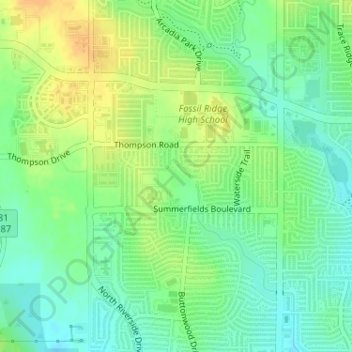
Name: Topografische Karte Summerfields/Chisholm Park, Höhe, Relief.
Durchschnittliche Höhe: 203 m
Minimale Höhe: 189 m
Maximale Höhe: 219 m
Andere topografische Karten
Klicken Sie auf eine Karte, um ihre Topografie, ihre Höhe und ihr Relief anzuzeigen.
Tarrant
United States > Texas > Tarrant County > Fort Worth
Tarrant, Fort Worth, Tarrant County, Texas, 76005, United States
Durchschnittliche Höhe: 155 m
Melody Hills
United States > Texas > Tarrant County > Fort Worth
Melody Hills, Fort Worth, Tarrant County, Texas, 76161, United States
Durchschnittliche Höhe: 191 m
Benbrook Lake
United States > Texas > Tarrant County > Fort Worth
Benbrook Lake, Fort Worth, Tarrant County, Texas, United States
Durchschnittliche Höhe: 230 m
Fort Worth
United States > Texas > Tarrant County > Fort Worth
Fort Worth, Tarrant County, Texas, 76102, United States
Durchschnittliche Höhe: 202 m
Rendon
United States > Texas > Tarrant County > Fort Worth
Rendon, Fort Worth, Tarrant County, Texas, United States
Durchschnittliche Höhe: 221 m
Will Rogers Memorial Center
United States > Texas > Tarrant County > Fort Worth
Will Rogers Memorial Center, Fort Worth, Tarrant County, Texas, United States
Durchschnittliche Höhe: 181 m
Magnolia Micro Park
United States > Texas > Tarrant County > Fort Worth
Magnolia Micro Park, Fort Worth, Tarrant County, Texas, United States
Durchschnittliche Höhe: 195 m