
Topografische Karte Center Junction
Interaktive Karte
Klicken Sie auf die Karte, um die Höhe anzuzeigen.
Über diese Karte
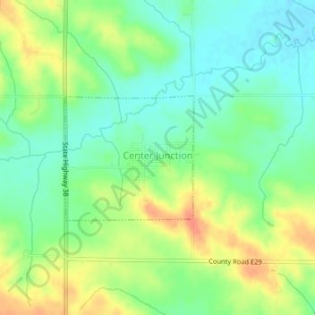
Name: Topografische Karte Center Junction, Höhe, Relief.
Ort: Center Junction, Jones County, Iowa, United States (42.11046 -91.09782 42.12117 -91.08290)
Durchschnittliche Höhe: 283 m
Minimale Höhe: 263 m
Maximale Höhe: 310 m
Andere topografische Karten
Klicken Sie auf eine Karte, um ihre Topografie, ihre Höhe und ihr Relief anzuzeigen.
Anamosa
United States > Iowa > Jones County
Anamosa, Jones County, Iowa, United States
Durchschnittliche Höhe: 260 m
Martelle
United States > Iowa > Jones County > Martelle
Martelle, Jones County, Iowa, United States
Durchschnittliche Höhe: 276 m
Morley
United States > Iowa > Jones County > Morley
Morley, Jones County, Iowa, 52312, United States
Durchschnittliche Höhe: 249 m
Onslow
United States > Iowa > Jones County > Onslow
Onslow, Jones County, Iowa, United States
Durchschnittliche Höhe: 277 m