
Spenden
Rüste dich für dein nächstes Abenteuer:
Als Amazon-Partner verdient diese Seite an qualifizierten Käufen, ohne dass Ihnen zusätzliche Kosten entstehen.
Topografische Karte Montpelier
Klicken Sie auf die Karte, um die Höhe anzuzeigen.
Spenden
Rüste dich für dein nächstes Abenteuer:
Als Amazon-Partner verdient diese Seite an qualifizierten Käufen, ohne dass Ihnen zusätzliche Kosten entstehen.
Montpelier
Montpelier is located in the north-central area of Vermont. The city center is a flat clay zone (elevation 520 ft; 160 m), surrounded by hills and granite ledges. Towne Hill runs in a 2-mile (3.2 km) ridge (~900 ft; 270 m) along the northern edge of the city.
Spenden
Rüste dich für dein nächstes Abenteuer:
Als Amazon-Partner verdient diese Seite an qualifizierten Käufen, ohne dass Ihnen zusätzliche Kosten entstehen.
Über diese Karte
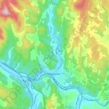
Name: Topografische Karte Montpelier, Höhe, Relief.
Ort: Montpelier, Washington County, Vermont, 05602, United States (44.23492 -72.61245 44.31331 -72.52509)
Durchschnittliche Höhe: 284 m
Minimale Höhe: 152 m
Maximale Höhe: 564 m
Spenden
Rüste dich für dein nächstes Abenteuer:
Als Amazon-Partner verdient diese Seite an qualifizierten Käufen, ohne dass Ihnen zusätzliche Kosten entstehen.
Andere topografische Karten
Klicken Sie auf eine Karte, um ihre Topografie, ihre Höhe und ihr Relief anzuzeigen.
Northfield Center
United States > Vermont > Washington County > Northfield
Durchschnittliche Höhe: 341 m
Northfield Falls
United States > Vermont > Washington County > Northfield
Durchschnittliche Höhe: 310 m
Spenden
Rüste dich für dein nächstes Abenteuer:
Als Amazon-Partner verdient diese Seite an qualifizierten Käufen, ohne dass Ihnen zusätzliche Kosten entstehen.
Northfield Center
United States > Vermont > Washington County > Northfield
Durchschnittliche Höhe: 341 m
Waterbury Center
United States > Vermont > Washington County > Waterbury
Durchschnittliche Höhe: 246 m
South Cabot
United States > Vermont > Washington County > Cabot > South Cabot
Durchschnittliche Höhe: 480 m
Spenden
Rüste dich für dein nächstes Abenteuer:
Als Amazon-Partner verdient diese Seite an qualifizierten Käufen, ohne dass Ihnen zusätzliche Kosten entstehen.