
Topografische Karte Simcoe County
Klicken Sie auf die Karte, um die Höhe anzuzeigen.
Simcoe County
The road network in Simcoe County is based on a grid pattern, with most roads running north–south or east–west. The topography of the land has permitted roads to be set in predominantly straight lines.
Über diese Karte
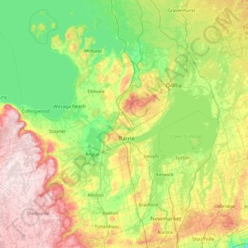
Name: Topografische Karte Simcoe County, Höhe, Relief.
Ort: Simcoe County, Central Ontario, Ontario, Canada (43.95141 -80.51594 44.94182 -79.08206)
Durchschnittliche Höhe: 265 m
Minimale Höhe: 145 m
Maximale Höhe: 540 m
Andere topografische Karten
Klicken Sie auf eine Karte, um ihre Topografie, ihre Höhe und ihr Relief anzuzeigen.
Toronto
Despite its deep ravines, Toronto is not remarkably hilly, but its elevation does increase steadily away from the lake. Elevation differences range from 76.5 metres (251 ft) above sea level at the Lake Ontario shore to 209 m (686 ft) ASL near the York University grounds in the city's north end at the…
Durchschnittliche Höhe: 113 m
London
Canada > Ontario > London > London
London has a humid continental climate (Köppen Dfb), though due to its downwind location relative to Lake Huron and elevation changes across the city, it is virtually on the Dfa/Dfb (hot summer) boundary favouring the former climate zone to the southwest of the confluence of the South and North Thames Rivers,…
Durchschnittliche Höhe: 268 m
Guelph
This region of Ontario has cold winters and warm, humid summers, falling into the Köppen climate classification Dfb zone, with moderately high rainfall and snowfall. It is generally a couple of degrees cooler than lower elevation regions on the Great Lakes shorelines, especially so in winter, the exception…
Durchschnittliche Höhe: 344 m
Peterborough
Canada > Ontario > Peterborough
Peterborough's topography is largely defined by land formations created by the receding Wisconsian glaciers 10,000–15,000 years ago. The South End and Downtown portions of the City sit on what was the bottom of the glacial Lake Peterborough—part of a glacial spillway created when glacial meltwaters from…
Durchschnittliche Höhe: 235 m
Sioux Narrows
Canada > Ontario > Kenora District > Sioux Narrows-Nestor Falls Township
Durchschnittliche Höhe: 329 m
Carroll Lake
Canada > Ontario > Kenora District > Unorganized Kenora District
Durchschnittliche Höhe: 338 m
Golden Lake
Canada > Ontario > Renfrew County > North Algona Wilberforce
Durchschnittliche Höhe: 185 m
Sunbow Lake
Canada > Ontario > Thunder Bay District > Unorganized Thunder Bay District
Durchschnittliche Höhe: 491 m
Little Straggle Lake
Canada > Ontario > Haliburton County > Dysart et al
Durchschnittliche Höhe: 433 m
Madawaska River
Canada > Ontario > Renfrew County > Greater Madawaska > Calabogie
Durchschnittliche Höhe: 160 m
Lorwall Lake
Canada > Ontario > Renfrew County > Brudenell, Lyndoch and Raglan
Durchschnittliche Höhe: 401 m
Glen Robertson
Canada > Ontario > Stormont, Dundas and Glengarry Counties > North Glengarry
Durchschnittliche Höhe: 78 m
Burditt Lake
Canada > Ontario > Kenora District > Unorganized Kenora District
Durchschnittliche Höhe: 367 m
Keswick
Canada > Ontario > York Region
Keswick's geographical coordinates are 44.22°N, 79.45°W, and its elevation above sea level is 221m/762 ft. It has a geographical area of 16.25 km² according to Statistics Canada. It is bound on the north by Roches Point, the east by Woodbine Avenue, the south by East Gwillimbury (Ravenshoe Road) and the…
Durchschnittliche Höhe: 228 m
London
London has a humid continental climate (Köppen Dfb), though due to its downwind location relative to Lake Huron and elevation changes across the city, it is virtually on the Dfa/Dfb (hot summer) boundary favouring the former climate zone to the southwest of the confluence of the South and North Thames Rivers,…
Durchschnittliche Höhe: 269 m
Key River
Canada > Ontario > Parry Sound District > Unorganized Centre Parry Sound
Durchschnittliche Höhe: 194 m
Memesagamesing Lake Dam
Canada > Ontario > Parry Sound District > Unorganized Centre Parry Sound
Durchschnittliche Höhe: 227 m
Port Loring
Canada > Ontario > Parry Sound District > Unorganized Centre Parry Sound
Durchschnittliche Höhe: 227 m
Dundas
Canada > Ontario > Hamilton > Dundas
Dundas /ˈdʌnˌdæs/ is a community and former town in Hamilton, Ontario, Canada. It is nicknamed the Valley Town because of its topographical location at the bottom of the Niagara Escarpment on the western edge of Lake Ontario. The population has been stable for decades at about twenty thousand, largely…
Durchschnittliche Höhe: 171 m
Weslemkoon Lake
Canada > Ontario > Lennox and Addington County > Addington Highlands
Durchschnittliche Höhe: 324 m
Frontenac Provincial Park
Canada > Ontario > South Frontenac
Frontenac Provincial Park is located near the town of Sydenham, north of the city of Kingston, Ontario, Canada. The Government of Ontario has classified Frontenac Provincial Park as a natural environment park. The park lies on the Frontenac Axis, a topographic extension of the Canadian Shield, which connects…
Durchschnittliche Höhe: 151 m
Rideau River Provincial Park
Canada > Ontario > Ottawa > Becketts Landing
Durchschnittliche Höhe: 89 m