
Topografische Karte Gedney Drove End
Klicken Sie auf die Karte, um die Höhe anzuzeigen.
Über diese Karte
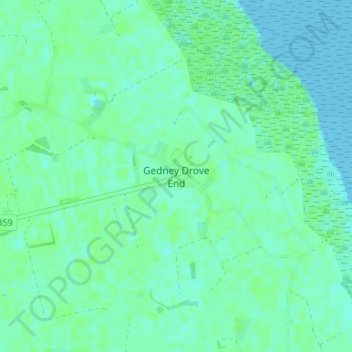
Name: Topografische Karte Gedney Drove End, Höhe, Relief.
Durchschnittliche Höhe: 4 m
Minimale Höhe: 0 m
Maximale Höhe: 8 m
Andere topografische Karten
Klicken Sie auf eine Karte, um ihre Topografie, ihre Höhe und ihr Relief anzuzeigen.
Deeping St. Nicholas
United Kingdom > England > Lincolnshire > South Holland > Deeping St Nicholas
Durchschnittliche Höhe: 3 m
Sutton St. Edmund
United Kingdom > England > Lincolnshire > South Holland > Sutton St Edmund
Durchschnittliche Höhe: 1 m
Long Sutton
United Kingdom > England > Lincolnshire > South Holland > Long Sutton
Durchschnittliche Höhe: 3 m
Crowland
United Kingdom > England > Lincolnshire > South Holland > Crowland
Durchschnittliche Höhe: 3 m
Sutton St. James
United Kingdom > England > Lincolnshire > South Holland > Sutton St James
Durchschnittliche Höhe: 2 m
Tydd St. Mary
United Kingdom > England > Lincolnshire > South Holland > Tydd St Mary
Durchschnittliche Höhe: 3 m