
Spenden
Rüste dich für dein nächstes Abenteuer:
Als Amazon-Partner verdient diese Seite an qualifizierten Käufen, ohne dass Ihnen zusätzliche Kosten entstehen.
Topografische Karte Stonor
Klicken Sie auf die Karte, um die Höhe anzuzeigen.
Spenden
Rüste dich für dein nächstes Abenteuer:
Als Amazon-Partner verdient diese Seite an qualifizierten Käufen, ohne dass Ihnen zusätzliche Kosten entstehen.
Über diese Karte
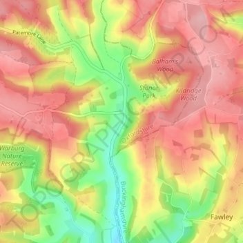
Name: Topografische Karte Stonor, Höhe, Relief.
Durchschnittliche Höhe: 145 m
Minimale Höhe: 63 m
Maximale Höhe: 204 m
Spenden
Rüste dich für dein nächstes Abenteuer:
Als Amazon-Partner verdient diese Seite an qualifizierten Käufen, ohne dass Ihnen zusätzliche Kosten entstehen.
Andere topografische Karten
Klicken Sie auf eine Karte, um ihre Topografie, ihre Höhe und ihr Relief anzuzeigen.
Clifton Hampden
United Kingdom > England > Oxfordshire > South Oxfordshire > Clifton Hampden
Durchschnittliche Höhe: 58 m
Spenden
Rüste dich für dein nächstes Abenteuer:
Als Amazon-Partner verdient diese Seite an qualifizierten Käufen, ohne dass Ihnen zusätzliche Kosten entstehen.
Harpsden Wood
United Kingdom > England > Oxfordshire > South Oxfordshire > Henley-on-Thames > Harpsden
Durchschnittliche Höhe: 63 m
Watlington Hill
United Kingdom > England > Oxfordshire > South Oxfordshire > Watlington
Durchschnittliche Höhe: 189 m
Kingwood Common
United Kingdom > England > Oxfordshire > South Oxfordshire > Highmoor
Durchschnittliche Höhe: 125 m
Spenden
Rüste dich für dein nächstes Abenteuer:
Als Amazon-Partner verdient diese Seite an qualifizierten Käufen, ohne dass Ihnen zusätzliche Kosten entstehen.
Goring-on-Thames
United Kingdom > England > Oxfordshire > South Oxfordshire > Goring-on-Thames
Durchschnittliche Höhe: 87 m
Cowleaze Wood
United Kingdom > England > Oxfordshire > South Oxfordshire > Lewknor
Durchschnittliche Höhe: 209 m
Spenden
Rüste dich für dein nächstes Abenteuer:
Als Amazon-Partner verdient diese Seite an qualifizierten Käufen, ohne dass Ihnen zusätzliche Kosten entstehen.
Sonning Eye
United Kingdom > England > Oxfordshire > South Oxfordshire > Dunsden Green > Sonning Eye
Durchschnittliche Höhe: 44 m
Sandford-on-Thames
United Kingdom > England > Oxfordshire > South Oxfordshire
Durchschnittliche Höhe: 68 m
Spenden
Rüste dich für dein nächstes Abenteuer:
Als Amazon-Partner verdient diese Seite an qualifizierten Käufen, ohne dass Ihnen zusätzliche Kosten entstehen.
Spenden
Rüste dich für dein nächstes Abenteuer:
Als Amazon-Partner verdient diese Seite an qualifizierten Käufen, ohne dass Ihnen zusätzliche Kosten entstehen.
Drayton St. Leonard
United Kingdom > England > Oxfordshire > South Oxfordshire
Durchschnittliche Höhe: 54 m
Brightwell-cum-Sotwell
United Kingdom > England > Oxfordshire > South Oxfordshire
Durchschnittliche Höhe: 54 m
Spenden
Rüste dich für dein nächstes Abenteuer:
Als Amazon-Partner verdient diese Seite an qualifizierten Käufen, ohne dass Ihnen zusätzliche Kosten entstehen.
Pill Pond
United Kingdom > England > Oxfordshire > South Oxfordshire > Didcot
Durchschnittliche Höhe: 71 m
Nuneham Courtenay
United Kingdom > England > Oxfordshire > South Oxfordshire
Durchschnittliche Höhe: 69 m
Little Wittenham
United Kingdom > England > Oxfordshire > South Oxfordshire
Durchschnittliche Höhe: 61 m
Spenden
Rüste dich für dein nächstes Abenteuer:
Als Amazon-Partner verdient diese Seite an qualifizierten Käufen, ohne dass Ihnen zusätzliche Kosten entstehen.
Kidmore End
United Kingdom > England > Oxfordshire > South Oxfordshire > Kidmore End
Durchschnittliche Höhe: 94 m
Spenden
Rüste dich für dein nächstes Abenteuer:
Als Amazon-Partner verdient diese Seite an qualifizierten Käufen, ohne dass Ihnen zusätzliche Kosten entstehen.
Horspath
United Kingdom > England > Oxfordshire > South Oxfordshire > Horspath
Durchschnittliche Höhe: 105 m
Spenden
Rüste dich für dein nächstes Abenteuer:
Als Amazon-Partner verdient diese Seite an qualifizierten Käufen, ohne dass Ihnen zusätzliche Kosten entstehen.
Berrick Salome
United Kingdom > England > Oxfordshire > South Oxfordshire
Durchschnittliche Höhe: 61 m
Chinnor Quarry 2B
United Kingdom > England > Oxfordshire > South Oxfordshire > Kingston Blount > Crowell
Durchschnittliche Höhe: 163 m
Whitchurch-on-Thames
United Kingdom > England > Oxfordshire > South Oxfordshire > Whitchurch-on-Thames
Durchschnittliche Höhe: 84 m
Edmonds Park
United Kingdom > England > Oxfordshire > South Oxfordshire > Didcot > East Hagbourne
Durchschnittliche Höhe: 68 m
Spenden
Rüste dich für dein nächstes Abenteuer:
Als Amazon-Partner verdient diese Seite an qualifizierten Käufen, ohne dass Ihnen zusätzliche Kosten entstehen.
Rotherfield Peppard
United Kingdom > England > Oxfordshire > South Oxfordshire > Rotherfield Peppard
Durchschnittliche Höhe: 115 m
Binfield Heath
United Kingdom > England > Oxfordshire > South Oxfordshire
Durchschnittliche Höhe: 73 m
Spenden
Rüste dich für dein nächstes Abenteuer:
Als Amazon-Partner verdient diese Seite an qualifizierten Käufen, ohne dass Ihnen zusätzliche Kosten entstehen.
Shirburn
United Kingdom > England > Oxfordshire > South Oxfordshire
Shirburn is a village and civil parish about 6 miles (10 km) south of Thame in Oxfordshire. It contains the Grade I listed, 14th-century Shirburn Castle, along with its surrounding, Grade II listed park, and a parish church, the oldest part of which is from the Norman period. The parish has a high altitude by…
Durchschnittliche Höhe: 140 m
Sonning Common
United Kingdom > England > Oxfordshire > South Oxfordshire > Sonning Common
Durchschnittliche Höhe: 88 m
Spenden
Rüste dich für dein nächstes Abenteuer:
Als Amazon-Partner verdient diese Seite an qualifizierten Käufen, ohne dass Ihnen zusätzliche Kosten entstehen.
Long Wittenham
United Kingdom > England > Oxfordshire > South Oxfordshire
Durchschnittliche Höhe: 55 m
Spenden
Rüste dich für dein nächstes Abenteuer:
Als Amazon-Partner verdient diese Seite an qualifizierten Käufen, ohne dass Ihnen zusätzliche Kosten entstehen.
East Hagbourne
United Kingdom > England > Oxfordshire > South Oxfordshire > East Hagbourne
Durchschnittliche Höhe: 62 m
Spenden
Rüste dich für dein nächstes Abenteuer:
Als Amazon-Partner verdient diese Seite an qualifizierten Käufen, ohne dass Ihnen zusätzliche Kosten entstehen.
Brightwell Baldwin
United Kingdom > England > Oxfordshire > South Oxfordshire > Cuxham
Durchschnittliche Höhe: 97 m
Stanton St John
United Kingdom > England > Oxfordshire > South Oxfordshire > Stanton St John
Durchschnittliche Höhe: 86 m
Spenden
Rüste dich für dein nächstes Abenteuer:
Als Amazon-Partner verdient diese Seite an qualifizierten Käufen, ohne dass Ihnen zusätzliche Kosten entstehen.
Spenden
Rüste dich für dein nächstes Abenteuer:
Als Amazon-Partner verdient diese Seite an qualifizierten Käufen, ohne dass Ihnen zusätzliche Kosten entstehen.
West Hagbourne
United Kingdom > England > Oxfordshire > South Oxfordshire
Durchschnittliche Höhe: 81 m
Spenden
Rüste dich für dein nächstes Abenteuer:
Als Amazon-Partner verdient diese Seite an qualifizierten Käufen, ohne dass Ihnen zusätzliche Kosten entstehen.
Swyncombe
United Kingdom > England > Oxfordshire > South Oxfordshire > Swyncombe
Durchschnittliche Höhe: 174 m
Britwell Salome
United Kingdom > England > Oxfordshire > South Oxfordshire
Durchschnittliche Höhe: 123 m
Aston Rowant Nature Reserve
United Kingdom > England > Oxfordshire > South Oxfordshire > Lewknor
Durchschnittliche Höhe: 192 m
Spenden
Rüste dich für dein nächstes Abenteuer:
Als Amazon-Partner verdient diese Seite an qualifizierten Käufen, ohne dass Ihnen zusätzliche Kosten entstehen.
Warborough
United Kingdom > England > Oxfordshire > South Oxfordshire > Warborough
Durchschnittliche Höhe: 53 m
Drayton St. Leonard
United Kingdom > England > Oxfordshire > South Oxfordshire
Durchschnittliche Höhe: 54 m
Clifton Hampden
United Kingdom > England > Oxfordshire > South Oxfordshire
Durchschnittliche Höhe: 58 m
Spenden
Rüste dich für dein nächstes Abenteuer:
Als Amazon-Partner verdient diese Seite an qualifizierten Käufen, ohne dass Ihnen zusätzliche Kosten entstehen.
Holly Wood
United Kingdom > England > Oxfordshire > South Oxfordshire > Stanton St John
Durchschnittliche Höhe: 80 m