
Topografische Karte Robla
Interaktive Karte
Klicken Sie auf die Karte, um die Höhe anzuzeigen.
Über diese Karte
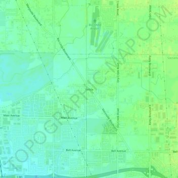
Name: Topografische Karte Robla, Höhe, Relief.
Durchschnittliche Höhe: 14 m
Minimale Höhe: 7 m
Maximale Höhe: 20 m
Andere topografische Karten
Klicken Sie auf eine Karte, um ihre Topografie, ihre Höhe und ihr Relief anzuzeigen.
Rosemont
United States > California > Sacramento County > Sacramento
Rosemont, Sacramento, Sacramento County, California, 95826, United States
Durchschnittliche Höhe: 18 m
Detention Pond
United States > California > Sacramento County > Sacramento
Detention Pond, Sacramento, Sacramento County, CAL Fire Northern Region, California, United States
Durchschnittliche Höhe: 5 m
Riverside
United States > California > Sacramento County > Sacramento
Riverside, Sacramento, Sacramento County, California, 95822, United States
Durchschnittliche Höhe: 7 m
Wild Rose Park
United States > California > Sacramento County > Sacramento
Wild Rose Park, Sacramento, Sacramento County, California, United States
Durchschnittliche Höhe: 7 m