Geolokalisieren

Topografische Karte Long Lake

Klicken Sie auf die Karte, um die Höhe anzuzeigen.

Über diese Karte

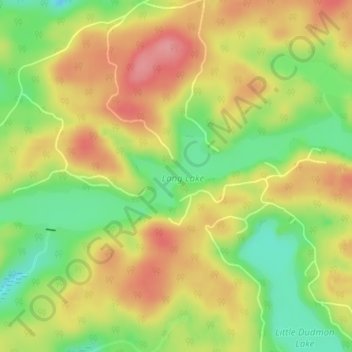
Name: Topografische Karte Long Lake, Höhe, Relief.

Ort: Long Lake, Dysart et al, Haliburton County, Central Ontario, Ontario, Canada (45.04511 -78.36268 45.04521 -78.36258)

Durchschnittliche Höhe: 415 m

Minimale Höhe: 363 m

Maximale Höhe: 462 m

Andere topografische Karten

Klicken Sie auf eine Karte, um ihre Topografie, ihre Höhe und ihr Relief anzuzeigen.

Kennisis Lake

Canada > Ontario > Haliburton County > Dysart et al

Durchschnittliche Höhe: 403 m

Benoir Lake

Canada > Ontario > Haliburton County > Dysart et al

Durchschnittliche Höhe: 395 m

Elephant Lake

Canada > Ontario > Haliburton County > Dysart et al

Durchschnittliche Höhe: 395 m

Two Islands Lake

Canada > Ontario > Haliburton County > Dysart et al

Durchschnittliche Höhe: 387 m

Percy Lake

Canada > Ontario > Haliburton County > Dysart et al

Durchschnittliche Höhe: 397 m

Lipsy Lake

Canada > Ontario > Haliburton County > Dysart et al

Durchschnittliche Höhe: 419 m

Grace Lake

Canada > Ontario > Haliburton County > Dysart et al

Durchschnittliche Höhe: 401 m

Miskwabi Dam

Canada > Ontario > Haliburton County > Dysart et al

Durchschnittliche Höhe: 407 m

Haliburton Lake

Canada > Ontario > Haliburton County > Dysart et al

Durchschnittliche Höhe: 392 m

Green Lake

Canada > Ontario > Haliburton County > Dysart et al > West Guilford

Durchschnittliche Höhe: 326 m

Redstone River

Canada > Ontario > Haliburton County > Dysart et al

Durchschnittliche Höhe: 469 m

Fishtail Lake

Canada > Ontario > Haliburton County > Dysart et al

Durchschnittliche Höhe: 427 m

McCrae Lake

Canada > Ontario > Haliburton County > Dysart et al

Durchschnittliche Höhe: 420 m

Scorch Lake

Canada > Ontario > Haliburton County > Dysart et al

Durchschnittliche Höhe: 436 m

Drag lake

Canada > Ontario > Haliburton County > Dysart et al > Haliburton

Durchschnittliche Höhe: 394 m

West Guilford

Canada > Ontario > Haliburton County > Dysart et al

Durchschnittliche Höhe: 333 m

Little Straggle Lake

Canada > Ontario > Haliburton County > Dysart et al

Durchschnittliche Höhe: 433 m

Tedious Lake

Canada > Ontario > Haliburton County > Dysart et al

Durchschnittliche Höhe: 408 m

Kennisis Lake

Canada > Ontario > Haliburton County > Dysart et al

Durchschnittliche Höhe: 403 m

Haliburton Lake

Canada > Ontario > Haliburton County > Dysart et al

Durchschnittliche Höhe: 392 m

Rüste dich für dein nächstes Abenteuer:

📶Satelliten‑Kommunikationsgeräte - Geräte für Notrufe und Kommunikation ohne Handynetz
👖Regen-Überhosen - Schneller Schutz, wenn das Wetter umschlägt
🦯Trekkingstöcke - Entlastung für die Knie beim Abstieg in steilem Gelände
🧴Outdoor-Sonnenschutz - Hoher Lichtschutzfaktor für strahlungsintensive Höhenlagen
🧭Outdoor-Kompasse - Klassische Orientierungshilfe für Kartenleser und Geografen

Als Amazon-Partner verdient diese Seite an qualifizierten Käufen, ohne dass Ihnen zusätzliche Kosten entstehen.