
Topografische Karte Bir
Interaktive Karte
Klicken Sie auf die Karte, um die Höhe anzuzeigen.
Über diese Karte
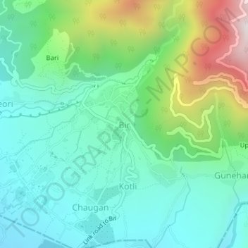
Name: Topografische Karte Bir, Höhe, Relief.
Ort: Bir, Baijnath, Kangra, Himachal Pradesh, India (32.04289 76.72085 32.04634 76.72725)
Durchschnittliche Höhe: 1’616 m
Minimale Höhe: 1’358 m
Maximale Höhe: 2’297 m
The paragliding launch site is in the meadow at Billing (14 km north of Bir), at an elevation of 2400 metres, while the landing site and most tourist accommodations are in the village of Chowgan (also spelled Chaugan), on the southern edge of Bir.