
Topografische Karte Lake Waco
Interaktive Karte
Klicken Sie auf die Karte, um die Höhe anzuzeigen.
Lake Waco
The average elevation of Lake Waco is held around 460 feet above sea level, with a typical fluctuation of 2–6 feet. Prior to the construction of the new dam, droughts and floods were common occurrences for the city of Waco. However, the new dam has proven to be the proper solution, as there has not been any serious floods since its installation. However, a 2011 study from the Texas Water Development Board found that Lake Waco loses between 206-334 acre-feet of capacity every year due to sediment deposition.
Über diese Karte
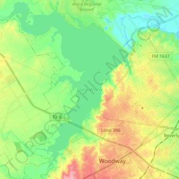
Name: Topografische Karte Lake Waco, Höhe, Relief.
Ort: Lake Waco, Waco, McLennan County, Texas, United States (31.49404 -97.29888 31.61117 -97.18973)
Durchschnittliche Höhe: 157 m
Minimale Höhe: 118 m
Maximale Höhe: 223 m
Andere topografische Karten
Klicken Sie auf eine Karte, um ihre Topografie, ihre Höhe und ihr Relief anzuzeigen.
Bosqueville
United States > Texas > McLennan County > Waco > Bosqueville
Durchschnittliche Höhe: 135 m