
Spenden
Rüste dich für dein nächstes Abenteuer:
Als Amazon-Partner verdient diese Seite an qualifizierten Käufen, ohne dass Ihnen zusätzliche Kosten entstehen.
Topografische Karte Down Under
Klicken Sie auf die Karte, um die Höhe anzuzeigen.
Spenden
Rüste dich für dein nächstes Abenteuer:
Als Amazon-Partner verdient diese Seite an qualifizierten Käufen, ohne dass Ihnen zusätzliche Kosten entstehen.
Über diese Karte
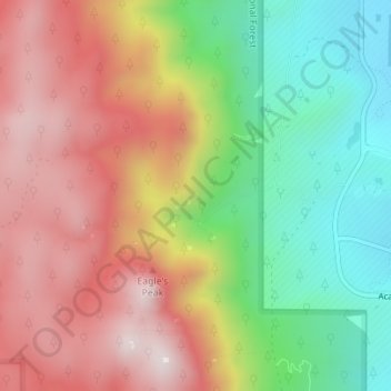
Name: Topografische Karte Down Under, Höhe, Relief.
Ort: Down Under, El Paso County, Colorado, United States (39.00628 -104.91141 39.00661 -104.91113)
Durchschnittliche Höhe: 2’500 m
Minimale Höhe: 2’159 m
Maximale Höhe: 2’843 m
Spenden
Rüste dich für dein nächstes Abenteuer:
Als Amazon-Partner verdient diese Seite an qualifizierten Käufen, ohne dass Ihnen zusätzliche Kosten entstehen.
Andere topografische Karten
Klicken Sie auf eine Karte, um ihre Topografie, ihre Höhe und ihr Relief anzuzeigen.
Colorado Springs
United States > Colorado > El Paso County
At 6,035 feet (1,839 m) the city stands over 1 mile (1.6 km) above sea level. Colorado Springs is near the base of Pikes Peak, which rises 14,115 feet (4,302.31 m) above sea level on the eastern edge of the Southern Rocky Mountains. The city is the largest city north of Mexico above 6000 feet in elevation.
Durchschnittliche Höhe: 2’252 m
Colorado Springs
United States > Colorado > El Paso County
Colorado Springs boasts a diverse and striking topography characterized by its high elevation and mountainous terrain. Nestled at approximately 6,035 feet (1,839 meters) above sea level, the city is flanked by the majestic Pikes Peak, which rises dramatically to 14,115 feet (4,302 meters), forming part of the…
Durchschnittliche Höhe: 2’252 m
Palmer Lake
United States > Colorado > El Paso County
The town marks the top of the Palmer Divide, a ridge running from Palmer Lake eastward which separates the Arkansas River drainage to the south from the Platte River drainage to the north. The highest point of the divide is about 7,700 feet (2,300 m) above sea level at Vollmer Hill located in the Black Forest.…
Durchschnittliche Höhe: 2’302 m
Spenden
Rüste dich für dein nächstes Abenteuer:
Als Amazon-Partner verdient diese Seite an qualifizierten Käufen, ohne dass Ihnen zusätzliche Kosten entstehen.
Pikes Peak
United States > Colorado > El Paso County
Pikes Peak or America's Mountain is an ultra-prominent fourteener of the Front Range of the Rocky Mountains of North America. Pikes Peak's summit has an elevation of 14,115 ft (4,302 m) above sea level. Pikes Peak is in Pike National Forest, Colorado, with the base located in the town of Manitou Springs, 10…
Durchschnittliche Höhe: 3’902 m
Spenden
Rüste dich für dein nächstes Abenteuer:
Als Amazon-Partner verdient diese Seite an qualifizierten Käufen, ohne dass Ihnen zusätzliche Kosten entstehen.
Spenden
Rüste dich für dein nächstes Abenteuer:
Als Amazon-Partner verdient diese Seite an qualifizierten Käufen, ohne dass Ihnen zusätzliche Kosten entstehen.
Spenden
Rüste dich für dein nächstes Abenteuer:
Als Amazon-Partner verdient diese Seite an qualifizierten Käufen, ohne dass Ihnen zusätzliche Kosten entstehen.
Rampart Reservoir
United States > Colorado > El Paso County
The reservoir supplies water to the Tesla Hydroelectric Facility. Colorado Springs Utilities built and operates this hydroelectric power plant, which opened in 1997. Water from the reservoir flows down a shaft called the Stanley Tunnel and then into the turbines in a powerhouse located in the foothills west of…
Durchschnittliche Höhe: 2’765 m
Garden of the Gods Park
United States > Colorado > El Paso County > Colorado Springs
Durchschnittliche Höhe: 1’982 m
Colorado Springs
United States > Colorado > El Paso County
Snowfall is usually moderate and remains on the ground briefly because of direct sun, with the city receiving 38 inches (97 cm) per season, although the mountains to the west often receive in excess of triple that amount; March is the snowiest month in the region, both by total accumulation and number of days…
Durchschnittliche Höhe: 2’229 m
Spenden
Rüste dich für dein nächstes Abenteuer:
Als Amazon-Partner verdient diese Seite an qualifizierten Käufen, ohne dass Ihnen zusätzliche Kosten entstehen.
Pikes Peak
United States > Colorado > El Paso County
The uppermost portion of Pikes Peak, above 14,000 feet (4,300 m) elevation, was declared a National Historic Landmark in 1961.
Durchschnittliche Höhe: 3’902 m
Palmer Lake
United States > Colorado > El Paso County
The town marks the top of the Palmer Divide, a ridge running from Palmer Lake eastward which separates the Arkansas River drainage to the south from the Platte River drainage to the north. The highest point of the divide is about 7,700 feet (2,300 m) above sea level at Vollmer Hill located in the Black Forest.…
Durchschnittliche Höhe: 2’302 m
Broadmoor
United States > Colorado > El Paso County > Colorado Springs
Durchschnittliche Höhe: 1’884 m
Spenden
Rüste dich für dein nächstes Abenteuer:
Als Amazon-Partner verdient diese Seite an qualifizierten Käufen, ohne dass Ihnen zusätzliche Kosten entstehen.
Colorado Springs
United States > Colorado > El Paso County
At 6,035 feet (1,839 m) the city stands over 1 mile (1.6 km) above sea level. Colorado Springs is near the base of Pikes Peak, which rises 14,115 feet (4,302.31 m) above sea level on the eastern edge of the Southern Rocky Mountains. The city is the largest city north of Mexico above 6000 feet in elevation.
Durchschnittliche Höhe: 2’252 m
Palmer Lake
United States > Colorado > El Paso County
The town marks the top of the Palmer Divide, a ridge running from Palmer Lake eastward which separates the Arkansas River drainage to the south from the Platte River drainage to the north. The highest point of the divide is about 7,700 feet (2,300 m) above sea level at Vollmer Hill located in the Black Forest.…
Durchschnittliche Höhe: 2’302 m
Spenden
Rüste dich für dein nächstes Abenteuer:
Als Amazon-Partner verdient diese Seite an qualifizierten Käufen, ohne dass Ihnen zusätzliche Kosten entstehen.
Colorado Springs
United States > Colorado > El Paso County
At 6,035 feet (1,839 m) the city stands over 1 mile (1.6 km) above sea level. Colorado Springs is near the base of Pikes Peak, which rises 14,115 feet (4,302.31 m) above sea level on the eastern edge of the Southern Rocky Mountains. The city is the largest city north of Mexico above 6000 feet in elevation.
Durchschnittliche Höhe: 2’252 m
Pikes Peak
United States > Colorado > El Paso County
Soils on Pikes Peak above the timberline (approximately 12,000 ft or 3,700 m) are classified as Cirque land. Forests at lower altitudes mostly lie over the brown stony, sandy, loams of the Catamount loam or Ivywild loam series.
Durchschnittliche Höhe: 3’902 m
Spenden
Rüste dich für dein nächstes Abenteuer:
Als Amazon-Partner verdient diese Seite an qualifizierten Käufen, ohne dass Ihnen zusätzliche Kosten entstehen.
Ben Lomand Mountain
United States > Colorado > El Paso County > Palmer Lake
Durchschnittliche Höhe: 2’220 m
Spenden
Rüste dich für dein nächstes Abenteuer:
Als Amazon-Partner verdient diese Seite an qualifizierten Käufen, ohne dass Ihnen zusätzliche Kosten entstehen.
Ben Lomand Mountain
United States > Colorado > El Paso County > Palmer Lake
Durchschnittliche Höhe: 2’220 m
Spenden
Rüste dich für dein nächstes Abenteuer:
Als Amazon-Partner verdient diese Seite an qualifizierten Käufen, ohne dass Ihnen zusätzliche Kosten entstehen.
Fountain
United States > Colorado > El Paso County > Fountain > Fountain
Durchschnittliche Höhe: 1’714 m
Garden of the Gods Park
United States > Colorado > El Paso County > Colorado Springs
Durchschnittliche Höhe: 1’982 m
Colorado Springs
United States > Colorado > El Paso County
At 6,035 feet (1,839 m) the city stands over 1 mile (1.6 km) above sea level. Colorado Springs is near the base of Pikes Peak, which rises 14,115 feet (4,302.31 m) above sea level on the eastern edge of the Southern Rocky Mountains. The city is the largest city north of Mexico above 6000 feet in elevation.
Durchschnittliche Höhe: 2’252 m
Spenden
Rüste dich für dein nächstes Abenteuer:
Als Amazon-Partner verdient diese Seite an qualifizierten Käufen, ohne dass Ihnen zusätzliche Kosten entstehen.