
Topografische Karte Jacksonville
Interaktive Karte
Klicken Sie auf die Karte, um die Höhe anzuzeigen.
Über diese Karte
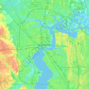
Name: Topografische Karte Jacksonville, Höhe, Relief.
Ort: Jacksonville, Duval County, Florida, 32202, United States (30.17218 -81.81565 30.49218 -81.49565)
Durchschnittliche Höhe: 9 m
Minimale Höhe: -5 m
Maximale Höhe: 31 m
Just south of Jacksonville and north of Saint Augustine is the boundary of where the Floridian Peninsula ends and Continental North America begins; Jacksonville is north of that line. While still in the North American Coastal plain, the topography begins to take on slight Piedmont characteristics. Like the Central Florida ridge and the Piedmont, the area begins sloping several miles inland. On the west side of Jacksonville, a series of low ridges predominate. The high point of Jacksonville rises to 190 feet above sea level on Trail Ridge, along the boundary with Baker County. This high point was developed into a landfill and leveled in the 1990s. Prior to that the ridge reached over 200 feet. Strip mining in the west side of Jacksonville has leveled the area.
Andere topografische Karten
Klicken Sie auf eine Karte, um ihre Topografie, ihre Höhe und ihr Relief anzuzeigen.
Pineland Gardens
United States > Florida > Duval County > Jacksonville
Pineland Gardens, Jacksonville, Duval County, Florida, 32216, United States
Durchschnittliche Höhe: 9 m