Geolokalisieren

Topografische Karte River Brock

Interaktive Karte

Klicken Sie auf die Karte, um die Höhe anzuzeigen.

Über diese Karte

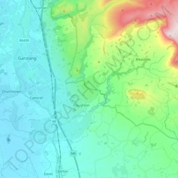
Name: Topografische Karte River Brock, Höhe, Relief.

Ort: River Brock, Borough of Wyre, Lancashire, England, United Kingdom (53.85582 -2.80986 53.90910 -2.62380)

Durchschnittliche Höhe: 111 m

Minimale Höhe: 7 m

Maximale Höhe: 519 m

Andere topografische Karten

Klicken Sie auf eine Karte, um ihre Topografie, ihre Höhe und ihr Relief anzuzeigen.

Hardhorn

United Kingdom > England > Lancashire > Borough of Wyre

Hardhorn, Borough of Wyre, Lancashire, England, FY6 8DN, United Kingdom

Durchschnittliche Höhe: 13 m

Little Thornton

United Kingdom > England > Lancashire > Borough of Wyre

Little Thornton, Borough of Wyre, Lancashire, England, FY5 5LU, United Kingdom

Durchschnittliche Höhe: 8 m

Parlick

United Kingdom > England > Lancashire > Borough of Wyre

Parlick, Borough of Wyre, Lancashire, England, PR3 2NZ, United Kingdom

Durchschnittliche Höhe: 251 m

Poulton-le-Fylde

United Kingdom > England > Lancashire > Borough of Wyre

Poulton-le-Fylde, Borough of Wyre, Lancashire, England, FY6 7BL, United Kingdom

Durchschnittliche Höhe: 12 m

St Michael's on Wyre

United Kingdom > England > Lancashire > Borough of Wyre

St Michael's on Wyre, Borough of Wyre, Lancashire, England, PR3 0TE, United Kingdom

Durchschnittliche Höhe: 10 m

Out Rawcliffe

United Kingdom > England > Lancashire > Borough of Wyre

Out Rawcliffe, Borough of Wyre, Lancashire, England, United Kingdom

Durchschnittliche Höhe: 10 m

Myerscough

United Kingdom > England > Lancashire > Borough of Wyre

Myerscough, Myerscough and Bilsborrow, Borough of Wyre, Lancashire, England, PR3 0RS, United Kingdom

Durchschnittliche Höhe: 17 m

Fleetwood

United Kingdom > England > Lancashire > Borough of Wyre

Fleetwood, Borough of Wyre, Lancashire, England, United Kingdom

Durchschnittliche Höhe: 2 m

Fair Snape Fell

United Kingdom > England > Lancashire > Borough of Wyre

Fair Snape Fell, Borough of Wyre, Lancashire, England, PR3 2NZ, United Kingdom

Durchschnittliche Höhe: 406 m

Garstang

United Kingdom > England > Lancashire > Borough of Wyre

Garstang, Borough of Wyre, Lancashire, England, United Kingdom

Durchschnittliche Höhe: 24 m

Great Eccleston

United Kingdom > England > Lancashire > Borough of Wyre

Great Eccleston, Borough of Wyre, Lancashire, England, United Kingdom

Durchschnittliche Höhe: 12 m

Bilsborrow

United Kingdom > England > Lancashire > Borough of Wyre

Bilsborrow, Myerscough and Bilsborrow, Borough of Wyre, Lancashire, England, PR3 0QR, United Kingdom

Durchschnittliche Höhe: 28 m

Preesall

United Kingdom > England > Lancashire > Borough of Wyre

Preesall, Borough of Wyre, Lancashire, England, United Kingdom

Durchschnittliche Höhe: 3 m

Hambleton

United Kingdom > England > Lancashire > Borough of Wyre > Hambleton

Hambleton, Borough of Wyre, Lancashire, North West England, England, United Kingdom

Durchschnittliche Höhe: 9 m

Catterall

United Kingdom > England > Lancashire > Borough of Wyre

Catterall, Borough of Wyre, Lancashire, England, PR3 0LR, United Kingdom

Durchschnittliche Höhe: 22 m

Oakenclough

United Kingdom > England > Lancashire > Borough of Wyre

Oakenclough, Bleasdale, Borough of Wyre, Lancashire, England, PR3 1UL, United Kingdom

Durchschnittliche Höhe: 206 m

Forton

United Kingdom > England > Lancashire > Borough of Wyre

Forton, Borough of Wyre, Lancashire, England, PR3 0BG, United Kingdom

Durchschnittliche Höhe: 30 m

Thornton

United Kingdom > England > Lancashire > Borough of Wyre

Thornton, Borough of Wyre, Lancashire, England, FY5 4AF, United Kingdom

Durchschnittliche Höhe: 7 m