
Topografische Karte Marys Peak
Interaktive Karte
Klicken Sie auf die Karte, um die Höhe anzuzeigen.
Über diese Karte
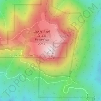
Name: Topografische Karte Marys Peak, Höhe, Relief.
Ort: Marys Peak, Benton County, Oregon, United States (44.50432 -123.55267 44.50442 -123.55257)
Durchschnittliche Höhe: 874 m
Minimale Höhe: 576 m
Maximale Höhe: 1’245 m
Andere topografische Karten
Klicken Sie auf eine Karte, um ihre Topografie, ihre Höhe und ihr Relief anzuzeigen.
Corvallis
United States > Oregon > Benton County
Corvallis, Benton County, Oregon, United States
Durchschnittliche Höhe: 81 m
Adair Village
United States > Oregon > Benton County
Adair Village, Benton County, Oregon, United States
Durchschnittliche Höhe: 100 m
Harris
United States > Oregon > Benton County
Harris, Benton County, Oregon, United States
Durchschnittliche Höhe: 257 m
Glenbrook
United States > Oregon > Benton County
Glenbrook, Benton County, Oregon, United States
Durchschnittliche Höhe: 180 m
Alpine
United States > Oregon > Benton County
Alpine, Benton County, Oregon, 97456, United States
Durchschnittliche Höhe: 112 m
Hoskins
United States > Oregon > Benton County
Hoskins, Benton County, Oregon, United States
Durchschnittliche Höhe: 191 m
Monroe
United States > Oregon > Benton County
Monroe, Benton County, Oregon, United States
Durchschnittliche Höhe: 99 m
Lewisburg
United States > Oregon > Benton County
Lewisburg, Benton County, Oregon, United States
Durchschnittliche Höhe: 101 m
Noon
United States > Oregon > Benton County
Noon, Benton County, Oregon, 97370, United States
Durchschnittliche Höhe: 143 m
Kings Valley
United States > Oregon > Benton County
Kings Valley, Benton County, Oregon, United States
Durchschnittliche Höhe: 125 m
Coast Range
United States > Oregon > Benton County
Coast Range, Benton County, Oregon, United States
Durchschnittliche Höhe: 824 m
Philomath
United States > Oregon > Benton County
Philomath, Benton County, Oregon, 97370, United States
Durchschnittliche Höhe: 104 m
Flynn
United States > Oregon > Benton County
Flynn, Benton County, Oregon, 97370, United States
Durchschnittliche Höhe: 124 m
Alder
United States > Oregon > Benton County
Alder, Benton County, Oregon, 97326, United States
Durchschnittliche Höhe: 244 m
Bellfountain
United States > Oregon > Benton County
Bellfountain, Benton County, Oregon, United States
Durchschnittliche Höhe: 107 m
Summit
United States > Oregon > Benton County
Summit, Benton County, Oregon, 96326, United States
Durchschnittliche Höhe: 218 m
Blodgett
United States > Oregon > Benton County
Blodgett, Benton County, Oregon, 97326, United States
Durchschnittliche Höhe: 230 m
Alsea
United States > Oregon > Benton County
Alsea, Benton County, Oregon, 97324, United States
Durchschnittliche Höhe: 154 m