
Topografische Karte Kalymnos
Interaktive Karte
Klicken Sie auf die Karte, um die Höhe anzuzeigen.
Über diese Karte
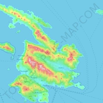
Name: Topografische Karte Kalymnos, Höhe, Relief.
Durchschnittliche Höhe: 75 m
Minimale Höhe: 0 m
Maximale Höhe: 658 m
Kalymnos is mostly mountainous with complicated topography. There are three main chains going from W-NW to E-SE, and a fourth which extends NW the length of the peninsula. The coastline is very irregular, with many sheltered coves. There are some springs, one among them being thermal. The soil is mainly limestone-based, but in the valleys, there is a compact bank of volcanic tuff, the relic of an ancient volcano, located in Vigles, between the villages of Myrties and Kantouni. The island is mainly barren, except for the two fertile valleys of Vathys and Pothia, where olives, oranges and vines are grown. There is also an ostrich farm in Argos, near the airport.
Andere topografische Karten
Klicken Sie auf eine Karte, um ihre Topografie, ihre Höhe und ihr Relief anzuzeigen.
Agathonisi
Greece > Aegean > Kalmynos Regional Unit > Megalo Chorio
Agathonisi, Megalo Chorio, Agathonisi Municipality, Kalmynos Regional Unit, South Aegean, Aegean, 850 01, Greece
Durchschnittliche Höhe: 20 m
Agia Thekla
Greece > Aegean > Kalmynos Regional Unit > Skala
Agia Thekla, Skala, Patmos Municipality, Kalmynos Regional Unit, South Aegean, Aegean, 855 00, Greece
Durchschnittliche Höhe: 19 m
Lipsi
Greece > Aegean > Kalmynos Regional Unit > Lipsi
Lipsi, Lipsi Municipality, Kalmynos Regional Unit, South Aegean, Aegean, 850 01, Greece
Durchschnittliche Höhe: 19 m
Pserimos
Greece > Aegean > Kalmynos Regional Unit > Pserimos
Pserimos, Municipality of Kalymnos, Kalmynos Regional Unit, South Aegean, Aegean, 852 00, Greece
Durchschnittliche Höhe: 29 m
Leros
Greece > Aegean > Kalmynos Regional Unit > Drymonas
Leros, Drymonas, Municipality of Leros, Kalmynos Regional Unit, South Aegean, Aegean, 854 00, Greece
Durchschnittliche Höhe: 30 m