
Topografische Karte Lake Huntington
Interaktive Karte
Klicken Sie auf die Karte, um die Höhe anzuzeigen.
Über diese Karte
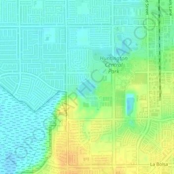
Name: Topografische Karte Lake Huntington, Höhe, Relief.
Durchschnittliche Höhe: 11 m
Minimale Höhe: -7 m
Maximale Höhe: 29 m
Andere topografische Karten
Klicken Sie auf eine Karte, um ihre Topografie, ihre Höhe und ihr Relief anzuzeigen.
Bolsa Chica Wetlands
United States > California > Orange County > Huntington Beach
Bolsa Chica Wetlands, Huntington Beach, Orange County, California, United States
Durchschnittliche Höhe: 7 m
Huntington Beach
United States > California > Orange County > Huntington Beach
Huntington Beach, Orange County, California, 92648, United States
Durchschnittliche Höhe: 16 m
Boulevard Gardens
United States > California > Orange County > Huntington Beach > Boulevard Gardens
Boulevard Gardens, Huntington Beach, Orange County, California, 92655, United States
Durchschnittliche Höhe: 10 m