
Spenden
Rüste dich für dein nächstes Abenteuer:
Als Amazon-Partner verdient diese Seite an qualifizierten Käufen, ohne dass Ihnen zusätzliche Kosten entstehen.
Topografische Karte Monarch Pass
Klicken Sie auf die Karte, um die Höhe anzuzeigen.
Spenden
Rüste dich für dein nächstes Abenteuer:
Als Amazon-Partner verdient diese Seite an qualifizierten Käufen, ohne dass Ihnen zusätzliche Kosten entstehen.
Monarch Pass
Monarch Pass (elevation 11,312 feet (3,448 m)) is a high mountain pass in central Colorado, in the Rocky Mountains of the western United States.
Spenden
Rüste dich für dein nächstes Abenteuer:
Als Amazon-Partner verdient diese Seite an qualifizierten Käufen, ohne dass Ihnen zusätzliche Kosten entstehen.
Über diese Karte
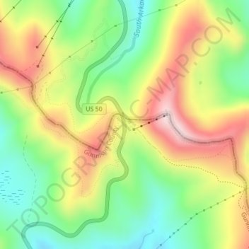
Name: Topografische Karte Monarch Pass, Höhe, Relief.
Ort: Monarch Pass, Gunnison County, Colorado, United States (38.49638 -106.32616 38.49648 -106.32606)
Durchschnittliche Höhe: 3’419 m
Minimale Höhe: 3’245 m
Maximale Höhe: 3’632 m
Spenden
Rüste dich für dein nächstes Abenteuer:
Als Amazon-Partner verdient diese Seite an qualifizierten Käufen, ohne dass Ihnen zusätzliche Kosten entstehen.
Andere topografische Karten
Klicken Sie auf eine Karte, um ihre Topografie, ihre Höhe und ihr Relief anzuzeigen.
Crested Butte
United States > Colorado > Gunnison County
At the 2020 United States Census, the town had a total area of 535 acres (2.166 km2), all of it land. Crested Butte lies at an elevation of 8,885 feet (2,708 m) above sea level.
Durchschnittliche Höhe: 2’798 m
Crested Butte
United States > Colorado > Gunnison County
Crested Butte is located in north-central Gunnison County on the west side of the valley of the Slate River, along Coal Creek. Colorado State Highway 135 runs south from Crested Butte 27 miles (43 km) to Gunnison, the county seat. According to the United States Census Bureau, the town of Crested Butte has a…
Durchschnittliche Höhe: 2’798 m
Spenden
Rüste dich für dein nächstes Abenteuer:
Als Amazon-Partner verdient diese Seite an qualifizierten Käufen, ohne dass Ihnen zusätzliche Kosten entstehen.
Crested Butte
United States > Colorado > Gunnison County
At the 2020 United States census, the town had a total area of 535 acres (2.166 km2), all of it land. Crested Butte lies at an elevation of 8,885 feet (2,708 m) above sea level.
Durchschnittliche Höhe: 2’798 m
Spenden
Rüste dich für dein nächstes Abenteuer:
Als Amazon-Partner verdient diese Seite an qualifizierten Käufen, ohne dass Ihnen zusätzliche Kosten entstehen.