Geolokalisieren

Topografische Karte Mapleton

Klicken Sie auf die Karte, um die Höhe anzuzeigen.

Über diese Karte

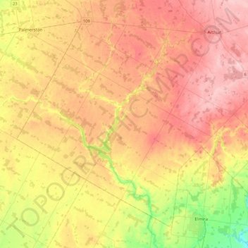
Name: Topografische Karte Mapleton, Höhe, Relief.

Ort: Mapleton, Wellington County, Southwestern Ontario, Ontario, Canada (43.58898 -80.87370 43.84545 -80.44942)

Durchschnittliche Höhe: 411 m

Minimale Höhe: 317 m

Maximale Höhe: 488 m

Andere topografische Karten

Klicken Sie auf eine Karte, um ihre Topografie, ihre Höhe und ihr Relief anzuzeigen.

Elora

Canada > Ontario > Wellington County > Centre Wellington

Durchschnittliche Höhe: 395 m

Belwood Quarry

Canada > Ontario > Wellington County > Centre Wellington

Durchschnittliche Höhe: 424 m

Mount Forest

Canada > Ontario > Wellington County > Wellington North

Durchschnittliche Höhe: 417 m

Fergus

Canada > Ontario > Wellington County > Centre Wellington

Durchschnittliche Höhe: 415 m

Rockwood

Canada > Ontario > Wellington County > Guelph/Eramosa

Durchschnittliche Höhe: 364 m

Alma

Canada > Ontario > Wellington County > Mapleton

Durchschnittliche Höhe: 445 m

Harriston

Canada > Ontario > Wellington County

Durchschnittliche Höhe: 386 m

Drayton

Canada > Ontario > Wellington County > Mapleton

Durchschnittliche Höhe: 419 m

Conn

Canada > Ontario > Wellington County > Wellington North

Durchschnittliche Höhe: 475 m

Elora Gorge

Canada > Ontario > Wellington County > Centre Wellington

Durchschnittliche Höhe: 385 m

Ballinafad

Canada > Ontario > Wellington County > Erin

Durchschnittliche Höhe: 374 m

Arthur

Canada > Ontario > Wellington County > Wellington North

Durchschnittliche Höhe: 460 m

Eramosa

Canada > Ontario > Wellington County > Guelph/Eramosa

Durchschnittliche Höhe: 361 m

Conestoga Lake

Canada > Ontario > Wellington County > Mapleton

Durchschnittliche Höhe: 412 m

Arthur

Canada > Ontario > Wellington County > Wellington North

Durchschnittliche Höhe: 460 m

Hillsburgh

Canada > Ontario > Wellington County > Erin

Durchschnittliche Höhe: 449 m

Mount Forest

Canada > Ontario > Wellington County > Wellington North

Durchschnittliche Höhe: 417 m

Fergus

Canada > Ontario > Wellington County > Centre Wellington

Durchschnittliche Höhe: 415 m

Inverhaugh

Canada > Ontario > Wellington County > Centre Wellington

Durchschnittliche Höhe: 356 m

Elora Gorge

Canada > Ontario > Wellington County > Centre Wellington

Durchschnittliche Höhe: 385 m

Aboyne

Canada > Ontario > Wellington County > Centre Wellington > Fergus

Durchschnittliche Höhe: 405 m

Elora

Canada > Ontario > Wellington County > Centre Wellington

Durchschnittliche Höhe: 395 m

Mount Forest

Canada > Ontario > Wellington County > Wellington North

Durchschnittliche Höhe: 417 m

Ballinafad

Canada > Ontario > Wellington County > Erin

Durchschnittliche Höhe: 374 m

Rüste dich für dein nächstes Abenteuer:

🌦️Regenjacken für Wanderer - Wasserdichte Jacken für wechselhaftes Wetter
🩴Wander‑Sandalen - Bequeme Sandalen für leichte Pfade und Wasserdurchquerungen
🗺️Wanderkarten Schweiz - Topografische und detaillierte Wanderkarten für alle Regionen der Schweiz
🧤Winter‑Outdoor‑Handschuhe - Warme Handschuhe für kalte Touren
🔥Campingkocher & Outdoor‑Kocher - Leistungsstarke Kocher für Wander‑ und Trekkingtouren

Als Amazon-Partner verdient diese Seite an qualifizierten Käufen, ohne dass Ihnen zusätzliche Kosten entstehen.