
Spenden
Rüste dich für dein nächstes Abenteuer:
Als Amazon-Partner verdient diese Seite an qualifizierten Käufen, ohne dass Ihnen zusätzliche Kosten entstehen.
Topografische Karte Tom London Dam
Klicken Sie auf die Karte, um die Höhe anzuzeigen.
Spenden
Rüste dich für dein nächstes Abenteuer:
Als Amazon-Partner verdient diese Seite an qualifizierten Käufen, ohne dass Ihnen zusätzliche Kosten entstehen.
Über diese Karte
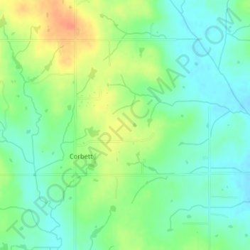
Name: Topografische Karte Tom London Dam, Höhe, Relief.
Ort: Tom London Dam, Cleveland County, Oklahoma, United States (34.97669 -97.22369 34.97679 -97.22359)
Durchschnittliche Höhe: 324 m
Minimale Höhe: 307 m
Maximale Höhe: 351 m
Spenden
Rüste dich für dein nächstes Abenteuer:
Als Amazon-Partner verdient diese Seite an qualifizierten Käufen, ohne dass Ihnen zusätzliche Kosten entstehen.
Andere topografische Karten
Klicken Sie auf eine Karte, um ihre Topografie, ihre Höhe und ihr Relief anzuzeigen.
Norman
United States > Oklahoma > Cleveland County
Norman and the surrounding areas are mostly flat with an elevation near 1,171 feet (357 m). The terrain in the western section of Norman is prairie, while the eastern section, including the area surrounding Lake Thunderbird, consists of some 6,000 acres (24 km2) of lakes and Cross Timbers forest. The lowest…
Durchschnittliche Höhe: 358 m
Lake Thunderbird
United States > Oklahoma > Cleveland County > Norman > Little Axe
Durchschnittliche Höhe: 334 m
Spenden
Rüste dich für dein nächstes Abenteuer:
Als Amazon-Partner verdient diese Seite an qualifizierten Käufen, ohne dass Ihnen zusätzliche Kosten entstehen.
Norman
United States > Oklahoma > Cleveland County
Norman and the surrounding areas are mostly flat with an elevation near 1,171 ft (357 m). The terrain in the western section of Norman is prairie, while the eastern section, including the area surrounding Lake Thunderbird, consists of some 6,000 acres (24 km2) of lakes and Cross Timbers forest. The lowest…
Durchschnittliche Höhe: 358 m
Sutton Urban Wilderness Park
United States > Oklahoma > Cleveland County > Norman
Durchschnittliche Höhe: 365 m
Spenden
Rüste dich für dein nächstes Abenteuer:
Als Amazon-Partner verdient diese Seite an qualifizierten Käufen, ohne dass Ihnen zusätzliche Kosten entstehen.
Norman
United States > Oklahoma > Cleveland County
Norman and the surrounding areas are mostly flat with an elevation near 1,171 ft (357 m). The terrain in the western section of Norman is prairie, while the eastern section, including the area surrounding Lake Thunderbird, consists of some 6,000 acres (24 km2) of lakes and Cross Timbers forest.
Durchschnittliche Höhe: 358 m
Spenden
Rüste dich für dein nächstes Abenteuer:
Als Amazon-Partner verdient diese Seite an qualifizierten Käufen, ohne dass Ihnen zusätzliche Kosten entstehen.