
Spenden
Rüste dich für dein nächstes Abenteuer:
Als Amazon-Partner verdient diese Seite an qualifizierten Käufen, ohne dass Ihnen zusätzliche Kosten entstehen.
Topografische Karte Adair
Klicken Sie auf die Karte, um die Höhe anzuzeigen.
Spenden
Rüste dich für dein nächstes Abenteuer:
Als Amazon-Partner verdient diese Seite an qualifizierten Käufen, ohne dass Ihnen zusätzliche Kosten entstehen.
Adair
Adair lies 10 miles (16 km) north of Pryor on U.S. Route 69 in Mayes County. The city is in the northeastern portion of the state known as "Green Country" and is near the borders of Kansas, Missouri, and Arkansas. Adair's geographic coordinates are 36°26′13″N 95°15′45″W / 36.43694°N 95.26250°W / 36.43694; -95.26250 (36.436910, -95.262546) with an elevation of 640 ft (200 m) above sea level. According to the United States Census Bureau, the town has a total area of 4.5 square miles (12 km2), all land.
Spenden
Rüste dich für dein nächstes Abenteuer:
Als Amazon-Partner verdient diese Seite an qualifizierten Käufen, ohne dass Ihnen zusätzliche Kosten entstehen.
Über diese Karte
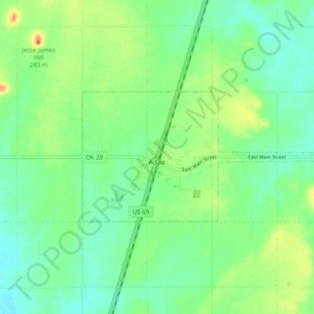
Name: Topografische Karte Adair, Höhe, Relief.
Ort: Adair, Mayes County, Oklahoma, 74330, United States (36.42344 -95.29204 36.45237 -95.20534)
Durchschnittliche Höhe: 206 m
Minimale Höhe: 190 m
Maximale Höhe: 235 m
Spenden
Rüste dich für dein nächstes Abenteuer:
Als Amazon-Partner verdient diese Seite an qualifizierten Käufen, ohne dass Ihnen zusätzliche Kosten entstehen.