
Topografische Karte Sydney
Interaktive Karte
Klicken Sie auf die Karte, um die Höhe anzuzeigen.
Über diese Karte
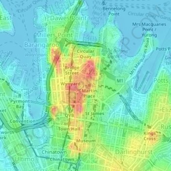
Name: Topografische Karte Sydney, Höhe, Relief.
Durchschnittliche Höhe: 22 m
Minimale Höhe: -4 m
Maximale Höhe: 88 m
Andere topografische Karten
Klicken Sie auf eine Karte, um ihre Topografie, ihre Höhe und ihr Relief anzuzeigen.
White Bay
Australia > New South Wales > Sydney
White Bay, Sydney, New South Wales, 2041, Australia
Durchschnittliche Höhe: 14 m
Cronulla Sand Dunes
Australia > New South Wales > Sydney
Cronulla Sand Dunes, Kurnell, Sutherland Shire, Sydney, Sutherland Shire Council, New South Wales, 2231, Australia
Durchschnittliche Höhe: 5 m
Cronulla Beach
Australia > New South Wales > Sydney
Cronulla Beach, Cronulla, Sutherland Shire, Sydney, Sutherland Shire Council, New South Wales, 2230, Australia
Durchschnittliche Höhe: 9 m
Wanda Beach
Australia > New South Wales > Sydney
Wanda Beach, Cronulla, Sutherland Shire, Sydney, Sutherland Shire Council, New South Wales, 2230, Australia
Durchschnittliche Höhe: 5 m
Elouera Beach
Australia > New South Wales > Sydney
Elouera Beach, Cronulla, Sutherland Shire, Sydney, Sutherland Shire Council, New South Wales, 2230, Australia
Durchschnittliche Höhe: 6 m
North Cronulla Beach
Australia > New South Wales > Sydney
North Cronulla Beach, Cronulla, Sutherland Shire, Sydney, Sutherland Shire Council, New South Wales, 2230, Australia
Durchschnittliche Höhe: 8 m
Rozelle
Australia > New South Wales > Sydney
Rozelle, Inner West, Sydney, Inner West Council, New South Wales, 2039, Australia
Durchschnittliche Höhe: 16 m
Bullaburra
Australia > New South Wales > Sydney
Bullaburra, Sydney, Blue Mountains City Council, New South Wales, 2784, Australia
Durchschnittliche Höhe: 712 m
Hurstville
Australia > New South Wales > Sydney
Hurstville, St George, Sydney, Georges River Council, New South Wales, 2220, Australia
Durchschnittliche Höhe: 50 m
Raging Waters Sydney
Australia > New South Wales > Sydney
Raging Waters Sydney, Western Motorway, Prospect, Sydney, Blacktown City Council, New South Wales, 2148, Australia
Durchschnittliche Höhe: 71 m
Ballast Point Park
Australia > New South Wales > Sydney
Ballast Point Park, Birchgrove, Inner West, Sydney, Inner West Council, New South Wales, 2041, Australia
Durchschnittliche Höhe: 11 m
Kensington
Australia > New South Wales > Sydney
Kensington, Eastern Suburbs, Sydney, Randwick City Council, New South Wales, 2033, Australia
Durchschnittliche Höhe: 31 m
Malabar
Australia > New South Wales > Sydney
Malabar, Eastern Suburbs, Sydney, Randwick City Council, New South Wales, 2036, Australia
Durchschnittliche Höhe: 24 m
Inner West
Australia > New South Wales > Sydney
Inner West, Sydney, Council of the City of Sydney, New South Wales, Australia
Durchschnittliche Höhe: 27 m
Avalon Beach
Australia > New South Wales > Sydney
Avalon Beach, Northern Beaches, Sydney, Northern Beaches Council, New South Wales, 2107, Australia
Durchschnittliche Höhe: 23 m
Cowan
Australia > New South Wales > Sydney
Cowan, Sydney, The Council of the Shire of Hornsby, New South Wales, 2081, Australia
Durchschnittliche Höhe: 90 m
Bradfield
Australia > New South Wales > Sydney > Bringelly
Bradfield, Bringelly, Sydney, Liverpool City Council, New South Wales, 2556, Australia
Durchschnittliche Höhe: 71 m
Glenwood
Australia > New South Wales > Sydney
Glenwood, Sydney, Blacktown City Council, New South Wales, 2768, Australia
Durchschnittliche Höhe: 69 m
Prospect
Australia > New South Wales > Sydney
Prospect, Sydney, Blacktown City Council, New South Wales, 2148, Australia
Durchschnittliche Höhe: 61 m
Iron Cove
Australia > New South Wales > Sydney
Iron Cove, Sydney, New South Wales, Australia
Durchschnittliche Höhe: 15 m
Harris Park
Australia > New South Wales > Sydney
Harris Park, Sydney, City of Parramatta Council, New South Wales, 2150, Australia
Durchschnittliche Höhe: 14 m
Browns Waterhole
Australia > New South Wales > Sydney
Browns Waterhole, South Turramurra, Upper North Shore, Sydney, Ku-ring-gai Council, New South Wales, 2074, Australia
Durchschnittliche Höhe: 73 m
Hornsby
Australia > New South Wales > Sydney
Hornsby, Sydney, The Council of the Shire of Hornsby, New South Wales, 2077, Australia
Durchschnittliche Höhe: 160 m
Hills District
Australia > New South Wales > Sydney
Hills District, Sydney, The Hills Shire Council, New South Wales, Australia
Durchschnittliche Höhe: 91 m
Normanhurst
Australia > New South Wales > Sydney
Normanhurst, Sydney, The Council of the Shire of Hornsby, New South Wales, 2076, Australia
Durchschnittliche Höhe: 165 m
Tambourine Bay
Australia > New South Wales > Sydney
Tambourine Bay, Sydney, New South Wales, 2110, Australia
Durchschnittliche Höhe: 25 m
Eastern Suburbs
Australia > New South Wales > Sydney
Eastern Suburbs, Sydney, Randwick City Council, New South Wales, Australia
Durchschnittliche Höhe: 13 m
Turramurra
Australia > New South Wales > Sydney
Turramurra, Upper North Shore, Sydney, Ku-ring-gai Council, New South Wales, 2074, Australia
Durchschnittliche Höhe: 143 m
Peakhurst Heights
Australia > New South Wales > Sydney
Peakhurst Heights, Sydney, Georges River Council, New South Wales, 2210, Australia
Durchschnittliche Höhe: 30 m
Richmond
Australia > New South Wales > Sydney
Richmond, Sydney, Hawkesbury City Council, New South Wales, 2753, Australia
Durchschnittliche Höhe: 18 m
Bottle and Glass Point
Australia > New South Wales > Sydney
Bottle and Glass Point, Vaucluse, Eastern Suburbs, Sydney, Woollahra Municipal Council, New South Wales, 2030, Australia
Durchschnittliche Höhe: 15 m
Upper North Shore
Australia > New South Wales > Sydney
Upper North Shore, Sydney, Ku-ring-gai Council, New South Wales, Australia
Durchschnittliche Höhe: 119 m
Sydney Water Supply Canal
Australia > New South Wales > Sydney
Sydney Water Supply Canal, Denham Court, Sydney, Campbelltown City Council, New South Wales, 2565, Australia
Durchschnittliche Höhe: 108 m
Woodford
Australia > New South Wales > Sydney
Woodford, Sydney, Blue Mountains City Council, New South Wales, 2778, Australia
Durchschnittliche Höhe: 544 m
Dantes Glen
Australia > New South Wales > Sydney > Lawson
Dantes Glen, Lawson, Sydney, Blue Mountains City Council, New South Wales, 2783, Australia
Durchschnittliche Höhe: 689 m
Henley
Australia > New South Wales > Sydney
Henley, Sydney, The Council of the Municipality of Hunters Hill, New South Wales, 2111, Australia
Durchschnittliche Höhe: 15 m
Camden
Australia > New South Wales > Sydney
Camden, Sydney, Camden Council, New South Wales, 2570, Australia
Durchschnittliche Höhe: 71 m
Ermington
Australia > New South Wales > Sydney
Ermington, Sydney, City of Parramatta Council, New South Wales, 2115, Australia
Durchschnittliche Höhe: 32 m
Lower North Shore
Australia > New South Wales > Sydney
Lower North Shore, Sydney, Willoughby City Council, New South Wales, Australia
Durchschnittliche Höhe: 45 m
Berowra
Australia > New South Wales > Sydney
Berowra, Sydney, The Council of the Shire of Hornsby, New South Wales, 2081, Australia
Durchschnittliche Höhe: 144 m
Balmoral Beach
Australia > New South Wales > Sydney
Balmoral Beach, Raglan Street, Balmoral, Mosman, Lower North Shore, Sydney, Mosman Municipal Council, New South Wales, 2088, Australia
Durchschnittliche Höhe: 36 m
Menai
Australia > New South Wales > Sydney
Menai, Sydney, Sutherland Shire Council, New South Wales, 2234, Australia
Durchschnittliche Höhe: 65 m
Bradleys Head
Australia > New South Wales > Sydney
Bradleys Head, Mosman, Lower North Shore, Sydney, Mosman Municipal Council, New South Wales, 2088, Australia
Durchschnittliche Höhe: 7 m
Newtown
Australia > New South Wales > Sydney
Newtown, Inner West, Sydney, Inner West Council, New South Wales, 2042, Australia
Durchschnittliche Höhe: 22 m
The Ponds
Australia > New South Wales > Sydney
The Ponds, Sydney, Blacktown City Council, New South Wales, 2769, Australia
Durchschnittliche Höhe: 60 m
Bella Vista
Australia > New South Wales > Sydney
Bella Vista, Sydney, The Hills Shire Council, New South Wales, 2153, Australia
Durchschnittliche Höhe: 79 m
Hawkesbury Panorama Reserve
Australia > New South Wales > Sydney > Hawkesbury Heights
Hawkesbury Panorama Reserve, Hawkesbury Heights, Sydney, Blue Mountains City Council, New South Wales, 2777, Australia
Durchschnittliche Höhe: 139 m
Beverly Hills
Australia > New South Wales > Sydney
Beverly Hills, St George, Sydney, Georges River Council, New South Wales, 2209, Australia
Durchschnittliche Höhe: 40 m
Marrickville
Australia > New South Wales > Sydney
Marrickville, Inner West, Sydney, Inner West Council, New South Wales, 2204, Australia
Durchschnittliche Höhe: 17 m
Bundeena
Australia > New South Wales > Sydney
Bundeena, Sydney, Sutherland Shire Council, New South Wales, 2230, Australia
Durchschnittliche Höhe: 20 m