
Topografische Karte Mayne
Klicken Sie auf die Karte, um die Höhe anzuzeigen.
Über diese Karte
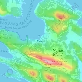
Name: Topografische Karte Mayne, Höhe, Relief.
Durchschnittliche Höhe: 52 m
Minimale Höhe: 0 m
Maximale Höhe: 241 m
Andere topografische Karten
Klicken Sie auf eine Karte, um ihre Topografie, ihre Höhe und ihr Relief anzuzeigen.
Mayne Island
Canada > British Columbia > Capital Regional District > Southern Gulf Islands Electoral Area > Mayne
Durchschnittliche Höhe: 26 m
Gulf Islands National Park Reserve
Canada > British Columbia > Capital Regional District > Southern Gulf Islands Electoral Area
Durchschnittliche Höhe: 57 m
Galiano Island
Canada > British Columbia > Capital Regional District > Southern Gulf Islands Electoral Area
Durchschnittliche Höhe: 24 m
Portland Island
Canada > British Columbia > Capital Regional District > Southern Gulf Islands Electoral Area
Durchschnittliche Höhe: 7 m
James Island
Canada > British Columbia > Capital Regional District > Southern Gulf Islands Electoral Area
James Island, one of British Columbia's Gulf Islands, lies in Haro Strait between Sidney Island and the coast of Vancouver Island near Sidney, British Columbia. James Island is approximately 2.4 km (1.5 mi) from the coast of Vancouver Island, and 145 km (90 mi) from Seattle, Washington. James Island has an…
Durchschnittliche Höhe: 8 m
North Pender Island
Canada > British Columbia > Capital Regional District > Southern Gulf Islands Electoral Area
Durchschnittliche Höhe: 23 m
Piers Island
Canada > British Columbia > Capital Regional District > Southern Gulf Islands Electoral Area
Durchschnittliche Höhe: 4 m
Saturna Island
Canada > British Columbia > Capital Regional District > Southern Gulf Islands Electoral Area
Durchschnittliche Höhe: 34 m
Buck Lake
Canada > British Columbia > Capital Regional District > Southern Gulf Islands Electoral Area
Durchschnittliche Höhe: 58 m
Pym Island
Canada > British Columbia > Capital Regional District > Southern Gulf Islands Electoral Area
Durchschnittliche Höhe: 2 m
Haro Strait
Canada > British Columbia > Capital Regional District > Southern Gulf Islands Electoral Area
Durchschnittliche Höhe: 24 m
North Pender Island
Canada > British Columbia > Capital Regional District > Southern Gulf Islands Electoral Area
Durchschnittliche Höhe: 23 m
Sidney Island
Canada > British Columbia > Capital Regional District > Southern Gulf Islands Electoral Area
Sidney Island is one of the southern Gulf Islands located between the southwest coast of British Columbia, Canada and Vancouver Island, BC, near James Island. Sidney Island has an elevation of 77 metres (252 feet 8 inches) above mean sea level at its highest point. It is located across Sidney Channel, just…
Durchschnittliche Höhe: 7 m
Mayne Island
Canada > British Columbia > Capital Regional District > Southern Gulf Islands Electoral Area > Mayne
Durchschnittliche Höhe: 26 m